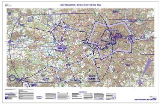
This chart is for the purpose of visual air navigation for helicopters within the London area, and can be also used in pre-flight planning and for pilot and navigator training. It depicts the current helicopter routes into and out of the London area, Heliports, Altitude Limits and reporting points. In addition to aeronautical information, the chart provides hydrographic, topographic, cultural and other visual features compatible with legibility at the scale of the chart. The source for all topographical detail is the GB Ordnance Survey 1:50,000 Landranger Map Series.
The Chart covers all the area of the London Control Zone and the western part of the London/City Control Zone.
In order to view the published amendments to the current chart either click on the chart or select from the list below.
A4 Legend
You will find a printable version of the Legend here.