Amendments for Southern England & Wales
Edition 51 effective 20 Mar 2025
The chart updates listed below are collected from a number of sources, and considered to be as reliable as possible. The Civil Aviation Authority whilst exercising great care in the compilation of this information, will not be responsible either for the accuracy or omissions therein. In the interests of safety, reference should always be made to the UK AIP, AICs, NOTAM and Pre-Flight Information Bulletins.
Chart users should refer here for the current list of En-Route Air Navigation Obstacles within the UK.
OBSTACLES WITHIN FRENCH TERRITORY HAVE NOW BEEN REMOVED FROM THE VFR CHARTS: refer to the France AIP here for latest data.
OBSTACLES WITHIN IRISH TERRITORY HAVE NOW BEEN REMOVED FROM THE VFR CHARTS: refer to the Ireland AIP here for the latest data.
VFR Chart Thumbnails
AIS have developed the following discretionary guidelines for the production of VFR Chart ‘thumbnails’ to supplement user guidance and notification of identified errors or changes within AIS products in cases where they are deemed to provide additional benefit. For example:
- When a significant chart error has been identified, requiring a NOTAM and/or correction via the AMDT Service and would be further supported by a thumbnail graphic.
- When the inclusion of a supporting thumbnail is deemed helpful to further mitigate the risk of possible ambiguity or misinterpretation of a chart update or correction.
- When complex airspace changes would be further supported by inclusion of a thumbnail.
- When a thumbnail will assist in clarifying an update to a particularly congested area of a chart.
Thumbnails will not be created as standard and remain at the discretion of AIS. CRs updating high instances of features will not require a thumbnail for each feature unless deemed appropriate. Airspace changes over large coverage areas shall be assessed on individual merit.
Thumbnails are only created and published once the amendment in question has been peer checked and approved.
Any questions or feedback relating to VFR Chart thumbnails please contact vfrcharts@nats.co.uk
Amendments Already Effective
| Reference | Effective | Details of Amendment | Correct Depiction (if Applicable) |
|---|---|---|---|
| 09446 | 29/11/2024 | HOSPITAL HELICOPTER LANDING SITES Addition of hospital helicopter landing sites to all VFR charts. See here and AIC G 026/2025 for full details. Sites will be indicated by the annotation HOSPITAL, along with the elevation; elevation only will be shown in extremely cluttered areas. |
|
| 09637 | 29/01/2025 | MIDHURST (MID) VOR 510314.23N 0003730.01W Declination updated from 0.3°E to 1.0°E. |
|
| 09791 | 11/03/2025 | WELSHPOOL (EGCW) Change Aerodrome Reference Point (ARP) and centre of Aerodrome Traffic Zone (ATZ) from 523743.15N 0030911.87W to 523743.03N 0030911.83W. |
|
| 09494/ 09541 |
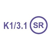
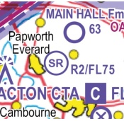
20/03/2025 | INTRODUCTION of a new symbol representing those kite flying sites, model aircraft flying sites and rocket launch sites named in UK AIP - ENR 5.5 AERIAL SPORTING AND RECREATIONAL ACTIVITIES. Annotations will show activity (indicated by designator K, M or R) with Maximum Altitude AMSL. See AIC G 026/2025 for further details. |  |
| 09602 | 20/03/2025 | REMOVAL of some foreign data from the UK VFR Charts: see AIC G 026/2025 for further details. | |
| 09603 | 20/03/2025 | FREQUENCY MONITORING CODES will be changed from blue text to magenta text: see AIC G 026/2025 for further details. | |
| 09929 | 10/04/2025 | MAYFIELD (MAY) VOR 510101.86N 0000658.04E Declination updated from 0.9°E to 1.4°E. |
|
| 09933 | 10/04/2025 | TRENT (TNT) VOR 530314.23N 0014011.90W Declination updated from 0.1°E to 0.4°E. |
|
| 09934 | 10/04/2025 | LAMBOURNE (LAM) VOR 513845.69N 0000906.13E Declination updated from 0.7°E to 1.1°E. |
|
| 09940 | 11/04/2025 | BROOKMANS PARK (BPK) VOR 514459.05N 0000624.25W Declination updated from 0.4°E to 1.2°E. |
|
| 10106 | 13/05/2025 | UK AIP - ENR 5.5 AERIAL SPORTING AND RECREATIONAL ACTIVITIES Amend the upper vertical limits for R2 Elsworth Rocket Site at 521500N 0000537W to FL75. |
 |
| 09599 | 15/05/2025 | UK AIP - ENR 5.5 AERIAL SPORTING AND RECREATIONAL ACTIVITIES HAREFIELD, Middlesex Add model aircraft flying site at 513730N 0002917W, with annotation M32/1.8 |
|
| 09600 | 15/05/2025 | UK AIP - ENR 5.5 AERIAL SPORTING AND RECREATIONAL ACTIVITIES WEYBOURNE, Norfolk Add model aircraft flying site at 525652N 0010724E, with annotation M33/1.6 |
|
| 09608 | 15/05/2025 | UK AIP - ENR 5.5 AERIAL SPORTING AND RECREATIONAL ACTIVITIES SYERSTON, Notts. Glider site at 530124N 0005442W: change all instances of frequency 128.525 to 128.530 |
|
| 09609 | 15/05/2025 | UK AIP - ENR 5.5 AERIAL SPORTING AND RECREATIONAL ACTIVITIES UPAVON, Wilts. Glider site at 511710N 0014652W: change all instances of frequency 124.100 to 124.105 |
|
| 09622 | 15/05/2025 | UK AIP - ENR 5.5 AERIAL SPORTING AND RECREATIONAL ACTIVITIES LITTLE RISSINGTON, Glos. Glider site at 515202N 0014139W: change all instances of frequency 120.775 to 120.780 |
|
| 09670 | 15/05/2025 | UK AIP - ENR 5.5 AERIAL SPORTING AND RECREATIONAL ACTIVITIES MARHAM, Norfolk Remove all references to glider site at 523854N 0003302E. |
|
| 10143 | 20/05/2025 | DOVER (DVR) VOR 510945.44N 0012132.71E Declination updated from 1.7°E to 1.4°E. |
|
| 10216 | 06/06/2025 | ODIHAM (EGVO) Govt./mil. aero site at 511403.09N 0005634.11W: change MATZ frequency from 131.300 to 131.305, and AD frequency from 131.305 to 119.230. |
|
| 09733 | 12/06/2025 | PETERBOROUGH/Conington (EGSF) Civil aero site at 522805N 0001503W: remove Aerodrome Traffic Zone (ATZ), and remove entry from 'UK AERODROME TRAFFIC ZONES (ATZ) SERVICES/RT FREQUENCIES' in chart legend. |
|
| 09764 | 12/06/2025 | UK AIP - ENR 5.1 PROHIBITED, RESTRICTED AND DANGER AREAS EGR219 Sandringham House Remove 'Note 30' from annotation on chart, remove Note 30 from Legend and renumber all subsequent notes. |
|
| 09819 | 12/06/2025 | UK AIP - ENR 5.1 PROHIBITED, RESTRICTED AND DANGER AREAS EGD220A Marham & EGD220B Marham New Danger Areas established. Both areas: a circle, 5NM radius, centred at 523854N 0003302E. D220A vertical limits SFC-FL105, D220B vertical limits FL105-FL195. Both areas: SUACS Marham ATC 124.155, SUAAIS London Information 126.400 MHz. |
|
| 09824 | 12/06/2025 | WESTCOTT (WCO) NDB Remove NDB WCO 335 at 515110.51N 0005744.67W due to withdrawal from service |
Amendments Yet To Become Effective
| Reference | Effective | Details of Amendment | Correct Depiction (if Applicable) |
|---|---|---|---|
| 09834 | 10/07/2025 | UK AIP - ENR 5.1 PROHIBITED, RESTRICTED AND DANGER AREAS EGD206 Cardington Remove Danger Area at 520621N 0002521W, and remove entries from SUACS and SUAAIS in chart legend and the Southern England & Wales Frequency Reference Card. |
|
| 09875 | 10/07/2025 | HALTON (EGWN) Govt./mil. aero site at 514733.00N 0004416.20W: change all instances of frequency 130.425 to 130.430. |
|
| 10077 | 07/08/2025 | UK AIP - ENR 5.1 PROHIBITED, RESTRICTED AND DANGER AREAS EGD147 Pontrilas & EGD216 Credenhill Add Air Ops Tel: 01432 357311 Ext 2369 to Pre-Flight Information in chart legend. |
|
| 10096 | 07/08/2025 | UK AIP - ENR 5.3 OTHER ACTIVITIES OF A DANGEROUS NATURE AND OTHER POTENTIAL HAZARDS Add the following laser sites: Camborne at 501306.8N 0051938.3W East Malling at 511715.4N 0002654.2E Exeter at 504340.8N 0033200.0W Rhyl at 531533.5N 0033031.3W Watnall at 530021.2N 0011500.8W All sites: radius 0.5NM, SFC-UNLTD, H24. |
|
| 10182 | 04/09/2025 | UK AIP - ENR 5.3 OTHER ACTIVITIES OF A DANGEROUS NATURE AND OTHER POTENTIAL HAZARDS Add the following laser site: Portsdown West at 505138N 0010747W Radius 0.25NM, SFC-1800ft AMSL, H24. |
|
| 10201 | 04/09/2025 | DONCASTER SHEFFIELD (EGCN) Civil aero site at 532831N 0010015W Remove all Doncaster Sheffield controlled airspace and annotations. Remove RMZ/TMZ. Remove VRP M1/M18 Thurcroft Interchange. Remove entries from legend tables Listening Squawks and UK Aerodrome Traffic Zones (ATZ) Services/RT Frequencies. Remove entries from Southern England & Wales Frequency Reference Card. |
|
| 10210 | 04/09/2025 | BRIZE NORTON (EGVN) Govt./mil. aerodrome at 514459.95N 0013458.61W: changes to Visual Reference Points (VRP). See here for full details. |
|
| 10221 | 04/09/2025 | UK AIP - ENR 5.5 AERIAL SPORTING AND RECREATIONAL ACTIVITIES RHIGOS, Powys Remove glider site, and replace on the chart with Rhigos unlicensed aerodrome at 514445N 0033513W, with elevation 803ft AMSL. |