Amendments for Northern England & Northern Ireland
Edition 48 effective 17 Apr 2025
The chart updates listed below are collected from a number of sources, and considered to be as reliable as possible. The Civil Aviation Authority whilst exercising great care in the compilation of this information, will not be responsible either for the accuracy or omissions therein. In the interests of safety, reference should always be made to the UK AIP, AICs, NOTAM and Pre-Flight Information Bulletins.
Chart users should refer here for the current list of En-Route Air Navigation Obstacles within the UK.
VFR Chart Thumbnails
AIS have developed the following discretionary guidelines for the production of VFR Chart ‘thumbnails’ to supplement user guidance and notification of identified errors or changes within AIS products in cases where they are deemed to provide additional benefit. For example:
- When a significant chart error has been identified, requiring a NOTAM and/or correction via the AMDT Service and would be further supported by a thumbnail graphic.
- When the inclusion of a supporting thumbnail is deemed helpful to further mitigate the risk of possible ambiguity or misinterpretation of a chart update or correction.
- When complex airspace changes would be further supported by inclusion of a thumbnail.
- When a thumbnail will assist in clarifying an update to a particularly congested area of a chart.
Thumbnails will not be created as standard and remain at the discretion of AIS. CRs updating high instances of features will not require a thumbnail for each feature unless deemed appropriate. Airspace changes over large coverage areas shall be assessed on individual merit.
Thumbnails are only created and published once the amendment in question has been peer checked and approved.
Any questions or feedback relating to VFR Chart thumbnails please contact vfrcharts@nats.co.uk
Amendments Already Effective
| Reference | Effective | Details of Amendment | Correct Depiction (if Applicable) |
|---|---|---|---|
| 09446 | 29/11/2024 | HOSPITAL HELICOPTER LANDING SITES Addition of hospital helicopter landing sites to all VFR charts. See here and AIC G 026/2025 for full details. Sites will be indicated by the annotation HOSPITAL, along with the elevation; elevation only will be shown in extremely cluttered areas. |
|
| 09494/ 09541 |
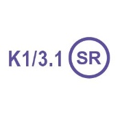
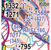
20/03/2025 | INTRODUCTION of a new symbol representing those kite flying sites, model aircraft flying sites and rocket launch sites named in UK AIP - ENR 5.5 AERIAL SPORTING AND RECREATIONAL ACTIVITIES. Annotations will show activity (indicated by designator K, M or R) with Maximum Altitude AMSL. See AIC G 026/2025 for further details. |  |
| 09602 | 20/03/2025 | REMOVAL of some foreign data from the UK VFR Charts: see AIC G 026/2025 for further details. | |
| 09603 | 20/03/2025 | FREQUENCY MONITORING CODES will be changed from blue text to magenta text: see AIC G 026/2025 for further details. | |
| 09933 | 10/04/2025 | TRENT (TNT) VOR 530314.23N 0014011.90W Declination updated from 0.1°E to 0.4°E. |
|
| 09935 | 11/04/2025 | TURNBERRY (TRN) VOR 551848.28N 0044701.91W Declination updated from 1.2°W to 0.9°W. |
|
| 10050 | 02/05/2025 | LEEDS BRADFORD (EGNM) Civil aero site at 535158N 0013939W: change elevation from 681ft AMSL to 682ft AMSL. |
|
| 10106 | 13/05/2025 | UK AIP - ENR 5.5 AERIAL SPORTING AND RECREATIONAL ACTIVITIES Amend the upper vertical limits for R1 Fairlie Moor Rocket Site at 554336N 0044840W to FL160. |
 |
| 09598 | 15/05/2025 | UK AIP - ENR 5.5 AERIAL SPORTING AND RECREATIONAL ACTIVITIES OUSTON, Newcastle Upon Tyne Add model aircraft flying site at 550125N 0015227W, with annotation M31/2.0 |
|
| 09606 | 15/05/2025 | UK AIP - ENR 5.5 AERIAL SPORTING AND RECREATIONAL ACTIVITIES KIRKNEWTON, Lothian Glider site at 555234N 0032400W: change all instances of frequency 124.100 to 124.105 |
|
| 09608 | 15/05/2025 | UK AIP - ENR 5.5 AERIAL SPORTING AND RECREATIONAL ACTIVITIES SYERSTON, Notts. Glider site at 530124N 0005442W: change all instances of frequency 128.525 to 128.530 |
|
| 09625 | 15/05/2025 | TOPCLIFFE (EGXZ) Govt./mil. aero site at 541220.26N 0012253.86W: change all instances of A/G frequency 121.450 to 121.455. |
|
| 09756 | 12/06/2025 | UK AIP - ENR 2.1 FIR, UIR, TMA AND CTA Changes to lateral limits of Strangford CTA 3. Refer to AIP for full details. |
|
| 09773 | 12/06/2025 | UK AIP - ENR 5.5 AERIAL SPORTING AND RECREATIONAL ACTIVITIES BALADO PARK Change microlight site at 561300N 0032737W to Training Aerodrome and change name to BALADO. Add contact frequency 118.605. Remove adjacent helicopter site BALADO as it is no longer in use. |
|
| 10259 | 13/06/2025 | IRELAND DONEGAL (EIDL) Civil aero site at 550239.00N 0082028.00W: change elevation from 31ft AMSL to 30ft AMSL. |
|
| 10096 | 07/08/2025 | UK AIP - ENR 5.3 OTHER ACTIVITIES OF A DANGEROUS NATURE AND OTHER POTENTIAL HAZARDS Add the following laser sites: Glasgow Bishopton at 555424.5N 0043157.7W Loftus at 543346.8N 0005143.2W Portglenone at 545155.0N 0062727.6 Rhyl at 531533.5N 0033031.3W Watnall at 530021.2N 0011500.8W All sites: radius 0.5NM, SFC-UNLTD, H24. |
|
| 10531 | 07/08/2025 | MANCHESTER (MCT) VOR 532125.29N 0021544.24W Declination updated from 0.1°E to 0.3°E. |
|
| 10548 | 11/08/2025 | WALNEY (EGNL) Add aerodrome beacon (star symbol) to civil aero site at 540743N 0031603W. |
|
| 10201 | 04/09/2025 | DONCASTER SHEFFIELD (EGCN) Civil aero site at 532831N 0010015W Change active licensed aerodrome symbol to disused/abandoned. Remove ICAO 4-letter code EGCN, elevation, AD frequency and navaid annotations. Remove all Doncaster Sheffield controlled airspace and annotations. Remove RMZ/TMZ. Remove VRPs Goole Docks, M1/M18 Thurcroft Interchange, A1/M18 Wadworth Interchange, M18 Stainforth Service and Haxey. Remove entries from legend tables 'Listening Squawks' and 'UK AERODROME TRAFFIC ZONES (ATZ) SERVICES/RT FREQUENCIES'. |
|
| 10161 | 04/09/2025 | UK AIP - ENR 1.6 ATS SURVEILLANCE SERVICES AND PROCEDURES Frequency Monitoring Codes Add FMC 7047 to Teesside International frequency 118.855 on the chart and the FMC table in the legend. |
|
| 10313 | 02/10/2025 | EDINBURGH (EGPH) VISUAL REFERENCE POINTS (VRP) Kirknewton at 555315.00N 0032505.00W: change to Kirknewton Railway Station at 555320.60N 0032600.20W. |
|
| 10362 | 02/10/2025 | GAMSTON (GAM) VOR 531653.28N 0005649.79W Remove VOR GAM due to withdrawal from service. DME to be retained. |
|
| 10944 | 27/11/2025 | BARKSTON HEATH (EGYE) Govt./mil. aero site at 525746.74N 0003337.16W: change all instances of TWR frequency 120.425 to 120.430. |
|
| 11102 | 05/12/2025 | GLASGOW (EGPF) Civil aero site at 555219N 0042559W: change all instances of APP frequency 119.100 to 119.105. |
|
| 11189 | 19/12/2025 | GLASGOW (GOW) VOR 555213.81N 0042644.60W Declination updated from 1.0°W to 0.8°W. |
|
| 11199 | 23/12/2025 | WOOD NOOK FARM Add unlicensed civil helicopter landing site at 533707.00N 0015404.00W, with elevation 755ft AMSL. |
|
| 11246 | 09/01/2026 | UK AIP - ENR 5.5 AERIAL SPORTING AND RECREATIONAL ACTIVITIES KIRTON-IN-LINDSEY, Lincs. Remove glider site at 532745N 0003436W due to closure of site. |
|
| 10862 | 22/01/2026 | LONDONDERRY/Eglinton (EAE) Civil aero site at 550234N 0070943W: change all instances of APP frequency 123.625 to 123.630. |