ENR 2.2 OTHER REGULATED AIRSPACE
| Name Lateral limits Vertical limits Class of Airspace | Unit ProvidingService | Callsign Language Hours of Service Conditions of Use | Frequency Channel Purpose | Remarks |
|---|---|---|---|---|
|
1 |
2 |
3 |
4 |
5 |
|
BARKSTON HEATH ATZ A circle, 2 NM radius, centred at 525747N 0003337W on longest notified runway (06/24) Upper limit: 2000 FT AGL Lower limit: SFC Class: G |
CRANWELL |
CRANWELL APPROACH English Mon-Thu 0830-1730 (0730-1630); Fri 0830-1700 (0730-1600). |
124.450 MHz ATC |
Elevation: 367 FT AMSL. |
|
BENSON ATZ A circle, 2 NM radius, centred at 513654N 0010545W on longest notified runway (01/19) Upper limit: 2000 FT AGL Lower limit: SFC Class: G |
BENSON |
BENSON ZONE English H24 |
120.900 MHz ATC |
Elevation: 203 FT AMSL. |
|
BOSCOMBE DOWN ATZ A circle, 2.5 NM radius, centred at 510912N 0014504W on longest notified runway (05/23) Upper limit: 2000 FT AGL Lower limit: SFC Class: G |
BOSCOMBE DOWN |
BOSCOMBE ZONE English Mon-Fri 0730-2359 (0630-2300); Sat-Sun SR-SS. |
126.700 MHz ATC |
Elevation: 407 FT AMSL. |
|
BRIZE NORTON ATZ A circle, 2.5 NM radius, centred at 514500N 0013459W on longest notified runway (08/26) Upper limit: 2000 FT AGL Lower limit: SFC Class: D |
BRIZE NORTON |
BRIZE ZONE English H24 |
119.000 MHz ATC |
Elevation: 287 FT AMSL. |
|
CONINGSBY ATZ A circle, 2.5 NM radius, centred at 530535N 0000958W on longest notified runway (07/25) Upper limit: 2000 FT AGL Lower limit: SFC Class: G |
CONINGSBY |
CONINGSBY APPROACH English H24 |
119.200 MHz ATC |
Elevation: 24 FT AMSL. |
|
COSFORD ATZ A circle, 2 NM radius, centred at 523826N 0021819W on longest notified runway (06/24) Upper limit: 2000 FT AGL Lower limit: SFC Class: G |
COSFORD |
COSFORD APPROACH English Mon-Fri 0900-1730 (0800-1630). |
135.875 MHz ATC |
Elevation: 272 FT AMSL. |
|
CRANWELL ATZ A circle, 2.5 NM radius, centred at 530147N 0002934W on longest notified runway (08/26) Upper limit: 2000 FT AGL Lower limit: SFC Class: G |
CRANWELL |
CRANWELL APPROACH English
Mon-Thu 0800-1730 (0700-1630); |
124.450 MHz ATC |
Elevation: 222 FT AMSL. |
|
CULDROSE ATZ A circle, 2.5 NM radius, centred at 500507N 0051515W on longest notified runway (11/29) Upper limit: 2000 FT AGL Lower limit: SFC Class: G |
CULDROSE |
CULDROSE APPROACH English H24 |
134.050 MHz ATC |
Elevation: 268 FT AMSL. |
|
EGPX FRA (AS PART OF BOREALIS FRA CONTINUUM) 610000N 0100000W following the line of latitude to - 610000N 0000000E - 600000N 0000000E - 570000N 0050000E - 550000N 0050000E - 543000N 0043209E - 543843N 0042000E - 544927N 0041110E - 550252N 0040000E - 552547N 0034557E - 552536N 0034259E - 552528N 0024830E - 552517N 0022451E - 552507N 0020850E - 552436N 0013246E - 552754N 0001453E - 552751N 0001521W - 552733N 0010125W - 552700N 0011023W - 552650N 0013354W - 552703N 0021345W - 552702N 0021836W - 552700N 0022627W - 552740N 0025947W - 552957N 0032110W - 553146N 0035631W - 552943N 0040436W - 552338N 0042825W - 550947N 0044512W - 550520N 0044907W - 544014N 0032836W - 542220N 0032542W - 540257N 0033104W - 535548N 0032947W - 535316N 0032923W - 535017N 0032855W - 534125N 0032734W - 534150N 0033649W - 535439N 0040737W - 535623N 0041926W - 535419N 0042151W - 535216N 0042414W - 534856N 0043030W - 534617N 0043112W - 534817N 0053000W - 535500N 0053000W - 540316N 0061212W - 542500N 0081000W - 543858N 0093320W - 543400N 0100000W - 610000N 0100000W Upper limit: FL660 Lower limit: FL255 Class: C |
SCOTTISH ACC |
SCOTTISH CONTROL English H24 |
121.325 MHz (Note 2 and 4) 125.680 MHz (Note 4) 126.930 MHz (Note 4) 129.100 MHz (Note 1 and 4) 129.225 MHz (Note 1, 3 and 5) 132.730 MHz (Note 4) 134.775 MHz (Note 2 and 4) 135.855 MHz (Note 4) |
Note 1: Scottish ACC is responsible for providing ATS between FL 245 and FL 660 within the Donegal Area. See ENR 2.2 Sect 1.8. |
|
EGTT FRA WEST (AS PART OF BOREALIS FRA CONTINUUM) 531149N 0053000W - 531111N 0050858W - 525542N 0041447W - 525436N 0032650W - 525334N 0031026W - 525350N 0025933W - 525340N 0025354W - 524754N 0024827W - 524148N 0023747W - 523450N 0023151W - 523253N 0023011W - 522103N 0021713W - 521524N 0021105W - 520831N 0020338W - 520355N 0015842W - 514723N 0014106W - 514215N 0014109W - 513941N 0013712W - 513505N 0013916W - 512808N 0014035W - 512423N 0014313W - 512036N 0013359W - 511306N 0013031W - 511238N 0013600W - 511527N 0020000W - 511506N 0020000W - 505543N 0020000W - 504947N 0023317W - 504749N 0023245W - 504459N 0023107W - 504055N 0023053W - 503949N 0023058W - 503712N 0021731W - 501745N 0022725W - 495458N 0023011W - 492841N 0045513W - 493500N 0080000W - 510000N 0080000W - 522000N 0053000W - 531149N 0053000W Upper limit: FL660 Lower limit: FL245 Class: C |
LONDON ACC |
LONDON CONTROL English H24 |
126.080 MHz 128.815 MHz 129.380 MHz (Note 1) 129.430 MHz 132.860 MHz 132.950 MHz (Note 1) 133.600 MHz 134.460 MHz 134.755 MHz 135.255 MHz (Note 1) |
Note 1: Shannon ACC is responsible for providing ATS between FL 195 and FL 660 within the BANBA CTA. See ENR 2.2 Sect 1.7. |
|
FAIRFORD ATZ A circle, 2.5 NM radius, centred at 514101N 0014724W on longest notified runway (09/27) Upper limit: 2000 FT AGL Lower limit: SFC Class: D |
BRIZE NORTON |
BRIZE ZONE English H24 |
119.000 MHz ATC |
Elevation: 285 FT AMSL. |
|
HALTON ATZ A circle, 2 NM radius, centred at 514732N 0004411W on longest notified runway (02/20) Upper limit: 2000 FT AGL Lower limit: SFC Class: G |
HALTON |
HALTON RADIO English 0900-2000 (0800-1900) or SS+15. |
130.425 MHz A/G |
Elevation: 369 FT AMSL. |
|
HONINGTON ATZ A circle, 2 NM radius, centred at 522036N 0004648E on longest notified runway (08/26) Upper limit: 2000 FT AGL Lower limit: SFC Class: G |
HONINGTON |
HONINGTON RADIO English Sat-Sun 0830-1700 (0730-1600). Other times by NOTAM. |
124.105 MHz A/G |
Elevation: 174 FT AMSL. |
|
LAKENHEATH ATZ A circle, 2.5 NM radius, centred at 522434N 0003340E on longest notified runway (06/24) Upper limit: 2000 FT AGL Lower limit: SFC Class: G |
LAKENHEATH |
LAKENHEATH RADAR English H24 |
128.900 MHz ATC |
Elevation: 32 FT AMSL. |
|
LEEMING ATZ A circle, 2.5 NM radius, centred at 541733N 0013207W on longest notified runway (16/34) Upper limit: 2000 FT AGL Lower limit: SFC Class: G |
LEEMING |
LEEMING ZONE English Mon-Thu 0800-1800 (0700-1700); Fri 0900-1700 (0800-1600). |
133.375 MHz ATC |
Elevation: 132 FT AMSL. |
|
LEUCHARS ATZ A circle, 2.5 NM radius, centred at 562230N 0025132W on longest notified runway (08/26) Upper limit: 2000 FT AGL Lower limit: SFC Class: G |
LEUCHARS |
LEUCHARS RADAR English H24 |
126.500 MHz ATC |
Elevation: 38 FT AMSL. |
|
LITTLE RISSINGTON ATZ A circle, 2 NM radius, centred at 515202N 0014139W on longest notified runway (04/22) Upper limit: 2000 FT AGL Lower limit: SFC Class: G |
LITTLE RISSINGTON |
RISSINGTON RADIO English Sat-Sun and Public Holidays 0830-1800 (0730-1700). |
120.775 MHz A/G |
Elevation: 731 FT AMSL. |
|
LOSSIEMOUTH ATZ A circle, 2.5 NM radius, centred at 574224N 0032016W on longest notified runway (05/23) Upper limit: 2000 FT AGL Lower limit: SFC Class: G |
LOSSIEMOUTH |
LOSSIE RADAR English H24 |
119.575 MHz ATC |
Elevation: 40 FT AMSL. |
|
MARHAM ATZ A circle, 2.5 NM radius, centred at 523854N 0003302E on longest notified runway (06/24) Upper limit: 2000 FT AGL Lower limit: SFC Class: G |
MARHAM |
MARHAM DIRECTOR English H24 |
124.150 MHz ATC |
Elevation: 76 FT AMSL. |
|
MERRYFIELD ATZ A circle, 2.5 NM radius, centred at 505747N 0025620W on longest notified runway (09/27) Upper limit: 2000 FT AGL Lower limit: SFC Class: G |
MERRYFIELD |
MERRYFIELD TOWER English By NOTAM. |
122.100 MHz ATC |
Elevation: 144 FT AMSL. |
|
MIDDLE WALLOP ATZ A circle, 2 NM radius, centred at 510828N 0013422W Upper limit: 2000 FT AGL Lower limit: SFC Class: G |
BOSCOMBE DOWN |
BOSCOMBE ZONE English H24 |
126.700 MHz ATC |
Elevation: 297 FT AMSL. |
|
MILDENHALL ATZ A circle, 2.5 NM radius, centred at 522143N 0002911E on longest notified runway (11/29) Upper limit: 2000 FT AGL Lower limit: SFC Class: G |
LAKENHEATH |
LAKENHEATH RADAR English H24 |
128.900 MHz ATC |
Elevation: 34 FT AMSL. |
|
MONA ATZ A circle, 2 NM radius, centred at 531533N 0042226W on longest notified runway (04/22) Upper limit: 2000 FT AGL Lower limit: SFC Class: G |
VALLEY |
VALLEY RADAR English Mon-Thu 0800-2359 (0700-2300); Fri-Sun 0800-2200 (0700-2100). |
125.225 MHz ATC |
Elevation: 202 FT AMSL. |
|
NETHERAVON ATZ A circle, 2 NM radius, centred at 511453N 0014517W on longest notified runway (11/29) Upper limit: 2000 FT AGL Lower limit: SFC Class: G |
NETHERAVON |
NETHERAVON INFORMATION English H24 |
128.300 MHz AFIS |
Elevation: 454 FT AMSL. |
|
NORTH SEA REDUCED COORDINATION AREA 552528N 0024830E - 545747N 0031350E - 541820N 0033908E - 533948N 0031120E - 531015N 0024622E - 531935N 0013046E - 532900N 0002406E - 534303N 0012559W - 541036N 0015420W - 543206N 0014419W - 545236N 0025346W - 551650N 0022600W - 552650N 0013354W - 552700N 0011023W - 552733N 0010125W - 552751N 0001521W - 552754N 0001453E - 552436N 0013246E - 552507N 0020850E - 552517N 0022451E - 552528N 0024830E Upper limit: FL660 Lower limit: FL195 Class: C |
LONDON ACC |
LONDON CONTROL English H24 |
126.780 MHz (Note 9) 128.130 MHz (Note 8) |
Within Controlled Airspace at all levels, inclusive of FL 195 to FL 245, except during periods of notified activation of TRA 5, 6, 7A, 7B. |
|
SCOTTISH ACC |
SCOTTISH CONTROL English H24 |
121.325 MHz (Note 2) 124.500 MHz (Note 7) 126.930 MHz (Note 3) 133.800 MHz (Note 6) 135.530 MHz (Note 4) 135.855 MHz (Note 5) | ||
|
NORTHOLT ATZ A circle, 2 NM radius, centred at 513310N 0002511W on longest notified runway (07/25). Upper limit: 2000 FT AGL Lower limit: SFC Class: D |
NORTHOLT |
NORTHOLT APPROACH English H24 |
126.450 MHz ATC |
Elevation 126 FT AMSL. |
|
ODIHAM ATZ A circle, 2 NM radius, centred at 511403N 0005634W on longest notified runway (09/27) Upper limit: 2000 FT AGL Lower limit: SFC Class: G |
ODIHAM |
ODIHAM APPROACH English H24 |
131.300 MHz ATC |
Elevation: 405 FT AMSL. |
|
PORTSMOUTH/FLEETLANDS ATZ 504810N 0010929W thence anti-clockwise by the arc of a circle radius 2 NM centred on 505007N 0011010W to 505054N 0011304W thence clockwise by the arc of a circle radius 2 NM centred on 504857N 0011224W to 505049N 0011117W - 504824N 0010921W thence clockwise by the arc of a circle radius 2 NM centred on 504857N 0011224W to 504810N 0010929W Upper limit: 2000 FT AGL Lower limit: SFC Class: G |
FLEETLANDS |
FLEETLANDS INFORMATION English Mon-Thu 0830-1700 (0730-1600), Fri 0830-1500 (0730-1400) or SS, whichever is earlier. |
135.705 MHz AFIS |
Elevation: 27 FT AMSL. |
|
PREDANNACK ATZ A circle, 2 NM radius, centred at 500007N 0051354W on longest notified runway (05/23) Upper limit: 2000 FT AGL Lower limit: SFC Class: G |
CULDROSE |
CULDROSE APPROACH English H24 |
134.050 MHz ATC |
Elevation: 299 FT AMSL. |
|
SHAWBURY ATZ A circle, 2 NM radius, centred at 524737N 0024005W on longest notified runway (18/36) Upper limit: 2000 FT AGL Lower limit: SFC Class: G |
SHAWBURY |
SHAWBURY ZONE English H24 |
133.150 MHz ATC |
Elevation: 248 FT AMSL. |
|
SYERSTON ATZ A circle, 2 NM radius, centred at 530124N 0005442W on longest notified runway (06/24) Upper limit: 2000 FT AGL Lower limit: SFC Class: G |
SYERSTON |
SYERSTON RADIO English
Mon-Fri (Excluding Public Holidays) 0830-1700 (0730-1600); |
128.525 MHz A/G |
Elevation: 231 FT AMSL. |
|
TERNHILL ATZ A circle, 2 NM radius, centred at 525223N 0023156W on longest notified runway (05/23) Upper limit: 2000 FT AGL Lower limit: SFC Class: G |
SHAWBURY |
SHAWBURY ZONE English Mon-Thu 0830-0230 (0730-0130); Fri 0800-1700 (0700-1600); Sat-Sun SR-SS+15. |
133.150 MHz ATC |
Elevation: 285 FT AMSL. |
|
TOPCLIFFE ATZ A circle, 2 NM radius, centred at 541220N 0012254W on longest notified runway (02/20) Upper limit: 2000 FT AGL Lower limit: SFC Class: G |
TOPCLIFFE |
TOPCLIFFE RADIO English Sat-Sun and Public Holidays 0830-SS+15 (0730-SS+15). |
121.450 MHz ATC |
Elevation: 91 FT AMSL. |
|
VALLEY ATZ A circle, 2.5 NM radius, centred at 531453N 0043207W on longest notified runway (13/31) Upper limit: 2000 FT AGL Lower limit: SFC Class: G |
VALLEY |
VALLEY RADAR English H24 |
125.225 MHz ATC |
Elevation: 37 FT AMSL. |
|
WADDINGTON ATZ A circle, 2.5 NM radius, centred at 530958N 0003126W on longest notified runway (02/20) Upper limit: 2000 FT AGL Lower limit: SFC Class: G |
WADDINGTON |
WADDINGTON ZONE English H24 |
119.500 MHz ATC |
Elevation: 230 FT AMSL. |
|
WATTISHAM ATZ A circle, 2.5 NM radius, centred at 520737N 0005719E on longest notified runway (05/23) Upper limit: 2000 FT AGL Lower limit: SFC Class: G |
WATTISHAM |
WATTISHAM APPROACH English H24 |
125.800 MHz ATC |
Elevation: 283 FT AMSL. |
|
WITTERING ATZ A circle, 2.5 NM radius, centred at 523647N 0002833W on longest notified runway (07/25) Upper limit: 2000 FT AGL Lower limit: SFC Class: G |
WITTERING |
WITTERING ZONE English H24 |
119.675 MHz
ATC |
Elevation: 273 FT AMSL. |
|
WOODVALE ATZ A circle, 2 NM radius, centred at 533454N 0030327W on longest notified runway (03/21) Upper limit: 2000 FT AGL Lower limit: SFC Class: G |
WOODVALE |
WOODVALE INFORMATION English Sun-Thu 0845-1745, or SS+30 (0745-1645, or SS+30) whichever is earlier. |
121.000 MHz AFIS |
Elevation: 37 FT AMSL. |
|
YEOVILTON ATZ 505817N 0024035W thence clockwise by the arc of a circle radius 2.5 NM centred on 510030N 0023844W to 505804N 0023747W - 505817N 0024035W Upper limit: 2000 FT AGL Lower limit: SFC Class: G |
YEOVILTON |
YEOVIL RADAR English H24 |
127.350 MHz ATC |
Elevation: 75 FT AMSL. |
1 AIRSPACE WITHIN WHICH ATS IS DELEGATED
1.1 The Areas Involved in the Transfer of ATS Responsibility Within the Northern North Sea at FL 85 and Below
In this part of the Polaris FIR, the United Kingdom will provide Air Traffic Services to all aircraft at FL 85 and below. Procedures and communications will be as if this airspace is an integral part of the Scottish FIR. This area is bounded by arcs of Great Circles joining in succession the following points:
590504N 0013916E - 600000N 0000000E - 630000N 0000000E following the line of latitude to - 630000N 0003120E - 625328N 0003821E - 622219N 0010622E - 614410N 0013329E - 612122N 0014718E - 595346N 0020430E - 591722N 0014236E - 590504N 0013916E.
In this part of the Scottish FIR, Norway will provide Air Traffic Services to all aircraft at FL 85 and below. Procedures and communications will be as if this airspace is an integral part of the Polaris FIR. This area is bounded by arcs of Great Circles joining in succession the following points:
590504N 0013916E - 570000N 0050000E - 563500N 0050000E - 560510N 0031455E - 563540N 0023642E - 575416N 0015748E - 582546N 0012854E - 590504N 0013916E.
In this airspace, contained within the North Sea Area II, a CTA of airspace Classification D has been established, in which Norway will provide Air Traffic Services to all aircraft at 1500 FT to FL 85. Procedures and communications will be as if this airspace is an integral part of the Polaris FIR. For lateral limits, please refer to CTA entry detailed in ENR 2.1.
In this airspace, contained within the North Sea Area II, a CTA of airspace Classification D has been established, in which Norway will provide Air Traffic Services to all aircraft at 1500 FT to FL 85. Procedures and communications will be as if this airspace is an integral part of the Polaris FIR. For lateral limits, please refer to CTA entry detailed in ENR 2.1. RMZ is SFC to 1500 FT ALT, please refer to ENR 2.2, paragraph 5.1 for lateral limits.
In this part of the Scottish FIR, Denmark will provide Air Traffic Services to all aircraft at FL 85 and below. Procedures and communications will be as if this airspace is an integral part of the Copenhagen FIR. This area is bounded by arcs of Great Circles joining in succession the following points:
563500N 0050000E - 550000N 0050000E - 551958N 0041955E - 554552N 0032208E - 555004N 0032355E - 555458N 0032055E - 560510N 0031455E - 563500N 0050000E.
In this part of the Reykjavik FIR/OCA, the United Kingdom will provide Air Traffic Services to all aircraft at FL 85 and below during the notified times of the Sumburgh Radar (Aberdeen ATSU) as listed at ENR 1.6, paragraph 4.5.2.2. Procedures and communications will be as if this airspace is an integral part of the Scottish FIR. This area is bounded by rhumb lines joining points (1) to (2) and points (3) to (4) and the arcs of Great Circles joining points (2) to (3) and points (4) to (1). The points within the Reykjavik FIR/OCA are:
(1) 610000N 0000000E following the line of latitude to -
(2) 610000N 0040000W -
(3) 630000N 0012637W following the line of latitude to -
(4) 630000N 0000000E -
(1) 610000N 0000000E.
Note: Class A FL 55 and above outside notified times.
1.2 The Area Involved in the Transfer of ATS Responsibility Within the Southern North Sea at FL 55 and Below
In these parts of the London and Scottish FIRs the Netherlands will provide Air Traffic Services to all aircraft at FL 55 and below (FL 45 and below, beneath EGD323D and EGD323E). Procedures and communications will be as if this airspace was an integral part of the Amsterdam FIR. This area is bounded (excluding the extreme south-eastern fillet of EGD323E) by the arcs of Great Circles joining in succession the following points:
550000N 0050000E - 551958N 0041955E - 554552N 0032208E - 543715N 0025349E - 542245N 0024543E - 535745N 0025155E - 534003N 0025719E - 533503N 0025913E - 532809N 0030055E - 531803N 0030319E - 525551N 0030936E - 550000N 0050000E.
Aircraft operating within Area V are strongly encouraged to contact Amsterdam ACC (on published frequencies, providing their position, altitude, squawk, heading and intentions) and strongly encouraged to ensure that transponders are switched on and operational in Mode 3/A and C/ALT.
1.3 The Area Involved in the Transfer of ATS Responsibility Within the North Sea High Area between FL 195 and FL 660 (inclusive)
In these parts of the London and Scottish UIRs/FIRs Denmark will provide Air Traffic Services to all aircraft between FL 195 and FL 660 (inclusive) in parts of the London and Scottish FIRs/UIRs to Denmark. Procedures and communications will be as if this airspace was an integral part of the Copenhagen FIR. This area is bounded by arcs of Great Circles joining in succession the following points:
570000N 0050000E - 550000N 0050000E - 543000N 0043209E - 543843N 0042000E - 544927N 0041110E - 550252N 0040000E - 555116N 0033000E - 563035N 0033000E - 572000N 0042958E - 570000N 0050000E.
1.4 The Area Involved in the Transfer of ATS Responsibility Within the Southern North Sea between FL 175 and FL 245 (inclusive).
FL 195 - FL 245 — Class C Airspace.
FL 175 - FL 195 — Class A Airspace.
In these parts of the London FIR the Netherlands will provide Air Traffic Services to all aircraft between FL 175 and FL 245 (inclusive) operating on ATS routes L17, L60, L74, L602, L989, M981, M982 and Y70. Procedures and communications will be as if this airspace was an integral part of the Amsterdam FIR.
1.5 The Area Involved in the Transfer of ATS Responsibility Within the Amsterdam FIR.
FL 245 - FL 660 — Class C Airspace (ATS - London Area Control (Swanwick)).
In these parts of the Amsterdam FIR the United Kingdom will provide Air Traffic Services to all aircraft between FL 245 and FL 660 (inclusive). Procedures and communications will be as if this airspace was an integral part of the London FIR/UIR. This area is bounded in succession by the following points:
515702.16N 0022122.62E - 515756.44N 0031018.61E - 512850.17N 0031018.61E - 514244.83N 0021001.17E - 515702.16N 0022122.62E
FL 215 - FL 245— Class C Airspace (ATS - London Terminal Control (Swanwick)).
In these parts of the Amsterdam FIR the United Kingdom will provide Air Traffic Services to all aircraft between FL 215 and FL 245 (inclusive). Procedures and communications will be as if this airspace was an integral part of the London FIR/UIR. This area is bounded in succession by the following points:
520027.05N 0031018.61E - 512850.17N 0031018.61E - 513812.59N 0023000.00E - 512720.12N 0023000.00E - 513000.00N 0020000.00E - 515709.71N 0022128.66E - 520027.05N 0031018.61E.
FL 195 - FL 215 — Class C Airspace (ATS - London Terminal Control (Swanwick)).
FL 55 - FL 195 — Class A Airspace (ATS - London Terminal Control (Swanwick)).
In these parts of the Amsterdam FIR the United Kingdom will provide Air Traffic Services to all aircraft between FL 55 and FL 215 (inclusive). Procedures and communications will be as if this airspace was an integral part of the London FIR/UIR. This area is bounded in succession by the following points:
515827.02N 0024000.87E - 513554.52N 0024000.87E - 513812.59N 0023000.00E - 512720.12N 0023000.00E - 513000.00N 0020000.00E - 515709.71N 0022128.66E - 515827.02N 0024000.87E.
FL 245 - FL 660 — Class C Airspace (ATS - London Area Control (Swanwick)).
In these parts of the Amsterdam FIR the United Kingdom will provide Air Traffic Services to all aircraft between FL 245 and FL 660 (inclusive). Procedures and communications will be as if this airspace was an integral part of the London FIR/UIR. This area is bounded in succession by the following points:
514244.83N 0021001.17E - 513812.59N 0023000.00E - 512720.12N 0023000.00E - 513000.00N 0020000.00E - 514244.83N 0021001.17E.
1.6 The Area Involved in the Transfer of ATS Responsibility Within the Southwestern Corner of the London UIR between FL 245 and FL 660 (inclusive)
In this part of the London UIR, France will provide Air Traffic Services to all aircraft between FL 245 and FL 660 (inclusive). Procedures and communications will be as if this airspace were an integral part of the France UIR. This area is bounded by arcs of Great Circles joining in succession the following points:
493323N 0065617W - 492841N 0045513W - 485542N 0073430W - 493323N 0065617W.
For FRA procedures see AIP France.
In this part of the London UIR, the Irish Republic will provide Air Traffic Services to all aircraft between FL 245 and FL 660 (inclusive). Procedures and communications will be as if this airspace were an integral part of the Shannon UIR. This area is bounded by arcs of Great Circles joining in succession the following points:
493500N 0080000W - 493323N 0065617W - 485542N 0073430W - 485000N 0080000W - 493500N 0080000W.
For FRA procedures see AIP Ireland.
1.7 The Area Involved in the Transfer of ATS Responsibility Within the Irish Sea
In this part of the London FIR, the Irish Republic will provide Air Traffic Services to all GAT. Procedures and communications will be as if this airspace were an integral part of the Shannon FIR.
In this part of the London FIR/UIR, the Irish Republic will provide Air Traffic Services to all GAT, between FL 195 and FL 660 (inclusive). Procedures and communications will be as if this airspace were an integral part of the Shannon UIR.
1.8 The Area Involved in the Transfer of ATS Responsibility Within the Shannon FIR/UIR
In this part of the Shannon UIR, the United Kingdom (Scottish AC (Prestwick)) will provide Air Traffic Services to all aircraft between FL 245 and FL 660 (inclusive). Procedures and communications will be as if this airspace were an integral part of the Scottish UIR. This area is bounded by arcs of Great Circles joining in succession the following points:
542500N 0081000W - 552000N 0065500W - 552500N 0072000W - 552000N 0081500W - 544500N 0090000W - 543858N 0093320W - 542500N 0081000W.
In this part of the Shannon FIR, the United Kingdom will provide Air Traffic Services to all aircraft between 1500 FT altitude and FL 75 (inclusive). Procedures and communications will be as if this airspace was an integral part of the Scottish FIR. This area is bounded in succession by the following points:
550527N 0071520W - 545506N 0072926W - 550205N 0073332W - 550527N 0071520W.
In this part of the Shannon FIR, the United Kingdom will provide Air Traffic Services to all aircraft between 2000 FT altitude and FL 75 (inclusive). Procedures and communications will be as if this airspace was an integral part of the Scottish FIR. This area is bounded in succession by the following points:
550205N 0073332W - 545506N 0072926W - 545212N 0073329W - 550114N 0073807W - 550205N 0073332W.
In this part of the Shannon FIR, the United Kingdom will provide Air Traffic Services to all aircraft between 3000 FT altitude and FL 75 (inclusive). Procedures and communications will be as if this airspace was an integral part of the Scottish FIR. This area is bounded in succession by the following points:
551217N 0070547W - 550527N 0071520W - 550317N 0072703W - Arc 10 NM radius centred on EGAE ARP (550234N 0070943W) - 551217N 0070547W.
1.9 The Area Involved in the Transfer of ATS Responsibility Within the North Atlantic
SFC - FL 195 — Class G Airspace.
FL 195 - FL 660 — Class C Airspace.
In this part of the Scottish FIR/UIR, Iceland (Reykjavik ACC) will provide Air Traffic Services to all aircraft between the surface and FL 660 (inclusive). Procedures and communications will be as if this airspace were an integral part of the Reykjavik FIR. The area is bounded by straight lines joining in succession the following points:
610000N 0070000W - 604000N 0100000W - 610000N 0100000W following the line of latitude to - 610000N 0070000W.
SFC - FL 195 — Class G Airspace.
FL 195 - FL 660 — Class C Airspace.
At the Scottish and Reykjavik FIR/UIR boundary, Iceland (Reykjavik ACC) will provide Air Traffic Services to all aircraft between the surface and FL 660 (inclusive). Procedures and communications will be as if this airspace were an integral part of the Reykjavik FIR. The area is a straight line joining the following points:
610000N 0000000E following the line of latitude to - 610000N 0070000W.
FL255 - FL660 — Class C Airspace.
In this part of the Scottish UIR, the Irish Republic (Shannon ACC) will provide Air Traffic Services to all aircraft between FL 255 and FL 660 (inclusive). Procedures and communications will be as if this airspace were an integral part of the Shannon UIR. The area is bounded by straight lines joining in succession the following points:
544311.750N 0100000.000W - 543857.730N 0093320.029W - 543400.000N 0100000.000W - 544311.750N 0100000.000W.
1.10 The Area Involved in the Transfer of ATS Responsibility Within the Paris FIR – La Manche Low.
1.10.1 La Manche East (Low) 1 – FL 115 - FL 265.
FL 115 - FL 195 — Class D Airspace (ATS - London Area Control (Swanwick)).
FL 195 - FL 265 — Class C Airspace (ATS - London Area Control (Swanwick)).
In these parts of the Paris FIR the United Kingdom will provide Air Traffic Services to all aircraft between FL 115 and FL 265 (inclusive). Procedures and communications will be as if this airspace was an integral part of the London FIR/UIR. The area is bounded by arcs of Great Circles joining in succession the following points:
504000N 0012800E - 503606N 0013218E - 501017N 0015131E - 500331N 0013906E - 501629N 0010108E - 502517N 0004917E - 504000N 0012800E.
1.10.2 La Manche East (Low) 2 – FL 195 - FL 265.
FL 195 - FL 265 — Class C Airspace (ATS - London Area Control (Swanwick)).
In these parts of the Paris FIR the United Kingdom will provide Air Traffic Services to all aircraft between FL 195 and FL 265 (inclusive). Procedures and communications will be as if this airspace was an integral part of the London FIR/UIR. The area is bounded by arcs of Great Circles joining in succession the following points:
501629N 0010108E - 500331N 0013906E - 495656N 0012709E - 501629N 0010108E.
1.10.3 La Manche East (Low) 3 – FL 115 - FL 265.
FL 115 - FL 195 — Class D Airspace (ATS - London Terminal Control (Swanwick)).
FL 195 - FL 265 — Class C Airspace (ATS - London Area Control (Swanwick)).
In these parts of the Paris FIR the United Kingdom will provide Air Traffic Services to all aircraft between FL 115 and FL 265 (inclusive). Procedures and communications will be as if this airspace was an integral part of the London FIR/UIR. The area is bounded by arcs of Great Circles joining in succession the following points:
505419N 0012754E - 504244N 0014405E - 503925N 0013811E - 503606N 0013218E - 504000N 0012800E - 505419N 0012754E.
1.11 The Area Involved in the Transfer of ATS Responsibility Within the Reims UIR – La Manche High Area.
1.11.1 La Manche East (High 1) - FL 265 - FL 285 — Class C Airspace.
In this part of the Reims UIR, the United Kingdom will provide Air Traffic Services to all aircraft between FL 265 and FL 285 (inclusive). Procedures and communications will be as if this airspace was an integral part of the London FIR/UIR. The area is bounded by arcs of Great Circles joining in succession the following points:
505419N 0012754E - 504244N 0014405E - 503925N 0013811E - 503606N 0013218E - 501346N 0015706E - 501017N 0015131E - 500659N 0014527E - 495656N 0012709E - 495951N 0012317E - 495841N 0011944E - 502405N 0004611E - 502517N 0004917E - 504000N 0012800E - 505419N 0012754E.
1.11.2 La Manche East (High 2) - FL 285 - FL 660 — Class C Airspace.
In this part of the Reims UIR, the United Kingdom will provide Air Traffic Services to all aircraft between FL 285 and FL 660 (inclusive). Procedures and communications will be as if this airspace was an integral part of the London FIR/UIR. The area is bounded by arcs of Great Circles joining in succession the following points:
505419N 0012754E - 504244N 0014405E - 503925N 0013811E - 503606N 0013218E - 501346N 0015706E - 501017N 0015131E - 500659N 0014527E - 495656N 0012709E - 495519N 0012412E - 495841N 0011944E - 502405N 0004611E - 502517N 0004917E - 504000N 0012800E - 505419N 0012754E.
1.12 The Area Involved in the Transfer of ATS Responsibility Within the London FIR – South-eastern Section of the English Channel.
1.12.1 Part of Lille TMA Area 7 - 1500 FT AMSL - FL 65 Class E Airspace (ATS Lille Approach).
In this part of the London FIR, France will provide Air Traffic Services to all aircraft between 1500 FT AMSL – FL 65 (inclusive). Procedures and communications will be as if this airspace was an integral part of the Paris FIR. The area is bounded by arcs of Great Circles joining in succession the following points:
503800N 0011500E - 504526N 0012800E - 504000N 0012800E - 503608N 0011744E - 503800N 0011500E.
1.13 The Area Involved in the Transfer of ATS Responsibility Within the London FIR – The Channel Islands.
In this part of the London FIR, Jersey will provide Air Traffic Services to all aircraft between FL 55 and FL 80 (inclusive). Procedures and communications will be as if this airspace was an integral part of the Channel Islands airspace which is delegated to Jersey from France during the opening hours of Jersey ATC. The area is bounded by arcs of Great Circles joining in succession the following points:
500000N 0030000W - 494951N 0030000W - 494802N 0031023W - 500000N 0032000W following the line of latitude to - 500000N 0030000W.
In this part of the London FIR, Jersey will provide Air Traffic Services to all aircraft between SFC and FL 80 (inclusive). Procedures and communications will be as if this airspace was an integral part of the Channel Islands airspace which is delegated to Jersey from France during the opening hours of Jersey ATC. The area is bounded by arcs of Great Circles joining in succession the following points:
500000N 0020000W - 494951N 0030000W - 500000N 0030000W following the line of latitude to - 500000N 0020000W.
In this part of the London FIR, Jersey will provide Air Traffic Services to all aircraft between FL 80 and FL 195 (inclusive). Procedures and communications will be as if this airspace was an integral part of the Channel Islands airspace which is delegated to Jersey from France during the opening hours of Jersey ATC. The area is bounded by arcs of Great Circles joining in succession the following points:
500000N 0020000W - 494802N 0031023W - 500000N 0032000W following the line of latitude to - 500000N 0020000W.
1.14 The Areas involved in the Transfer of ATS Responsibility are marked on the charts at ENR 6-44 to ENR 6-58.
2 MILITARY AERODROME TRAFFIC ZONES
2.1 Description
The airspace within 5 NM radius of the mid-point of the longest runway, from the surface to 3000 FT AAL.
The airspace within a stub or stubs projected from the above airspace, having a length of 5 NM along the centre-line(s) aligned with the selected final approach path(s), and a width of 4 NM (2 NM either side of the centre-line) from 1000 FT AAL to 3000 FT AAL.
Exceptions to the above exist; however, for details of the dimensions of specific zones and the associated stub(s) see paragraph 2.4 and ENR 6-59 (chart).
2.2 Procedures for Penetration of a MATZ
When 15 NM or 5 minutes flying time from the zone boundary, whichever is the greater, establish two-way RTF communication with the controlling aerodrome on the appropriate frequency using the phraseology:
'..... (controlling aerodrome), this is ..... (aircraft callsign), request MATZ (and ATZ) penetration.'
when the call is acknowledged and when asked to 'pass your message', the pilot should pass the following information:
Callsign;
Type of aircraft;
Position;
Heading;
Altitude;
Intentions (eg destination and the intention to route through one or more ATZ);
comply with any instructions issued by the controller;
maintain a listening watch on the allocated RTF frequency until the aircraft is clear of the MATZ/ATZ;
advise the controller when the aircraft is clear of the MATZ/ATZ.
Note 1: Flight conditions are not required unless requested by the controller.
Note 2: Terrain clearance will be the responsibility of the pilot.
Note 3: Since compliance is not compulsory for civil aircraft some aircraft within the MATZ may not be known to the controller. All pilots should therefore maintain a good look-out at all times.
Note: Given that military aircrew observance of a MATZ and associated ATC requirements are mandatory, MATZ penetration by a military aircraft is subject to specific permission/clearance.
2.3 Availability of the MATZ Penetration Service
2.4 MATZ Participating Aerodromes
|
MATZ Designation/ |
AD |
MATZ Core Radius/Limits |
1st Stub |
2nd Stub |
Controlling |
Hours of applicability |
Remarks |
|---|---|---|---|---|---|---|---|
|
1 |
2 |
3 |
4 |
5 |
6 |
7 |
8 |
|
Barkston Heath |
367 |
Radius: 3 NMUpper Limit: 3000 FT AGLLower Limit: SFC |
058 2 NM Upper Limit: 3000 FT AGL Lower Limit: 1000 FT AGL | — |
Cranwell CRANWELL APRROACH 124.450 MHz English |
— |
— |
|
Benson |
203 |
Radius: 5 NMUpper Limit: 3000 FT AGLLower Limit: SFC |
008 5 NM Upper Limit: 3000 FT AGL Lower Limit: 1000 FT AGL |
188 5 NM Upper Limit: 3000 FT AGL Lower Limit: 1000 FT AGL |
Benson BENSON ZONE 120.900 MHz English |
— | — |
|
Boscombe Down |
407 |
Radius: 5 NMUpper Limit: 3000 FT AGLLower Limit: SFC |
050 5 NM Upper Limit: 3000 FT AGL Lower Limit: 1000 FT AGL |
230 5 NM Upper Limit: 3000 FT AGL Lower Limit: 1000 FT AGL |
Boscombe Down BOSCOME ZONE 126.700 MHz English |
— |
If Boscombe Down is closed but Middle Wallop remains open, a CMATZ penetration service will be provided by Wallop Approach on 126.700 MHz. |
|
Coningsby |
24 |
Radius: 5 NMUpper Limit: 3000 FT AGLLower Limit: SFC |
252 5 NM Upper Limit: 3000 FT AGL Lower Limit: 1000 FT AGL | — |
Coningsby CONINGSBY APPROACH 119.200 MHz English |
— | — |
|
Cranwell |
222 |
Radius: 5 NMUpper Limit: 3000 FT AGLLower Limit: SFC |
263 5 NM Upper Limit: 3000 FT AGL Lower Limit: 1000 FT AGL | — |
Cranwell CRANWELL APPROACH 124.450 MHz English |
— | — |
|
Culdrose 500507.43N 0051514.66W |
268 |
Radius: 5 NMUpper Limit: 3000 FT AGLLower Limit: SFC |
293 5 NM Upper Limit: 3000 FT AGL Lower Limit: 1000 FT AGL | — |
Culdrose CULDROSE APPROACH 134.050 MHz English |
— | Culdrose Combined MATZ is formed with the Predannack MATZ, based on the Culdrose QFE. |
|
Fairford |
285 |
Radius: 5 NMUpper Limit: 3000 FT AGLLower Limit: SFC |
268 5 NM Upper Limit: 3000 FT AGL Lower Limit: 1000 FT AGL | — |
Brize Norton BRIZE ZONE 119.000 MHz English |
NOTAM or Supplement |
This aerodrome is open on very limited occasions when advised by NOTAM or Supplement. |
|
Lakenheath |
32 |
Radius: 5 NMUpper Limit: 3000 FT AGLLower Limit: SFC |
056 5 NM Upper Limit: 3000 FT AGL Lower Limit: SFC |
236 5 NM Upper Limit: 3000 FT AGL Lower Limit: 1000 FT AGL |
Lakenheath LAKENHEATH RADAR 128.900 MHz English |
— |
Helicopters tasked to operate in EGD208 are required to call Lakenheath ATC to notify intended entry to EGD208 prior to penetrating the CMATZ. No restrictions will be imposed by Lakenheath on helicopters which operate within that portion of their north-easterly stub which is also within the lateral limits of EGD208, provided that the aircraft remain at or below 800 FT AMSL.Within the Lakenheath/Mildenhall MATZ the pressure setting used will be the Lakenheath QNH. |
|
Leeming |
132 |
Radius: 5 NMUpper Limit: 3000 FT AGLLower Limit: SFC |
156 5 NM Upper Limit: 3000 FT AGL Lower Limit: 1000 FT AGL | — |
Leeming LEEMING ZONE 133.375 MHz English | — | — |
|
Leuchars |
38 |
Radius: 5 NMUpper Limit: 3000 FT AGLLower Limit: SFC |
082 5 NM Upper Limit: 3000 FT AGL Lower Limit: 1000 FT AGL |
262 5 NM Upper Limit: 3000 FT AGL Lower Limit: 1000 FT AGL |
Leuchars LEUCHARS RADAR 126.500 MHz English |
— | — |
|
Lossiemouth |
40 |
Radius: 5 NMUpper Limit: 3000 FT AGLLower Limit: SFC |
224 5 NM Upper Limit: 3000 FT AGL Lower Limit: 1000 FT AGL | — |
Lossiemouth LOSSIE RADAR 119.575 MHz English |
— | — |
|
Marham |
76 |
Radius: 5 NMUpper Limit: 3000 FT AGLLower Limit: SFC |
057 5 NM Upper Limit: 3000 FT AGL Lower Limit: 1000 FT AGL |
237 5 NM Upper Limit: 3000 FT AGL Lower Limit: 1000 FT AGL |
Marham MARHAM DIRECTOR 124.150 MHz English |
— | — |
|
Merryfield |
144 |
Radius: 3 NMUpper Limit: 3000 FT AGLLower Limit: SFC |
— |
— |
Yeovilton YEOVIL RADAR 127.350 MHz English |
— |
— |
|
Middle Wallop |
297 |
Radius: 5 NMUpper Limit: 3000 FT AGLLower Limit: SFC |
256 3 NM Upper Limit: 3000 FT AGL Lower Limit: 1000 FT AGL | — |
Boscombe Down BOSCOME ZONE 126.700 MHz English |
— |
Non-standard reference point aligned with common radar touchdown point.If Boscombe Down is closed but Middle Wallop remains open, a CMATZ penetration service will be provided by Wallop Approach on 126.700 MHz. |
|
Mildenhall |
34 |
Radius: 5 NMUpper Limit: 3000 FT AGLLower Limit: SFC |
103 5 NM Upper Limit: 3000 FT AGL Lower Limit: 1000 FT AGL See Remark |
283 5 NM Upper Limit: 3000 FT AGL Lower Limit: 1000 FT AGL See Remark |
Lakenheath LAKENHEATH RADAR 128.900 MHz English |
— |
Non-standard extension to both stubs - 5 NM south of extended centre-lines.Non-standard demarcation of the 5 NM circles which are joined by a straight line at their most easterly points.Within the Lakenheath/Mildenhall MATZ the pressure setting used will be the Lakenheath QNH. |
|
Mona |
202 |
Radius: 5 NMUpper Limit: 3000 FT AGLLower Limit: SFC |
— |
— |
Valley VALLEY RADAR 125.225 MHz English |
— | — |
|
Odiham |
405 |
Radius: 5 NMUpper Limit: 3000 FT AGLLower Limit: SFC |
093 5 NM Upper Limit: 3000 FT AGL Lower Limit: 1000 FT AGL | — |
Odiham ODIHAM APPROACH 131.300 MHz English |
— |
Odiham Approach, except weekends and PH, when the task may be carried out by Farnborough on Frequency 125.250 MHz.Within the Odiham MATZ the transit pressure setting will be the Farnborough QNH. |
|
Predannack |
299 |
Radius: 5 NMUpper Limit: 3000 FT AGLLower Limit: SFC |
— |
— |
Culdrose CULDROSE APPROACH 134.050 MHz English |
— | Predannack MATZ forms part of the Culdrose Combined MATZ, based on the Culdrose QFE. |
|
Shawbury |
248 |
Radius: 5 NMUpper Limit: 3000 FT AGLLower Limit: SFC |
180 5 NM Upper Limit: 3000 FT AGL Lower Limit: 1000 FT AGL |
360 5 NM Upper Limit: 3000 FT AGL Lower Limit: 1000 FT AGL |
Shawbury SHAWBURY ZONE 133.150 MHz English |
— | — |
|
Ternhill |
285 |
Radius: 5 NMUpper Limit: 3000 FT AGLLower Limit: SFC |
— |
— |
Shawbury SHAWBURY ZONE 133.150 MHz English |
— |
Weekend and out of hours,freecall Ternhill Radio for aerodromeinformation freq 122.100 MHz. |
|
Topcliffe |
91 |
Radius: 5 NMUpper Limit: 3000 FT AGLLower Limit: SFC |
— |
— |
Leeming LEEMING ZONE 133.375 MHz English |
— | — |
|
Valley |
37 |
Radius: 5 NMUpper Limit: 3000 FT AGLLower Limit: SFC |
130 5 NM Upper Limit: 3000 FT AGL Lower Limit: 1000 FT AGL | — |
Valley VALLEY 125.225 MHz English |
— | — |
|
Waddington |
230 |
Radius: 5 NMUpper Limit: 3000 FT AGLLower Limit: SFC |
202 5 NM Upper Limit: 3000 FT AGL Lower Limit: 1000 FT AGL | — |
Waddington WADDINGTON ZONE 119.500 MHz English |
— | — |
|
Warton |
54 |
See Remark |
See Remark |
See Remark |
Warton WARTON RADAR 129.530 MHz English |
— |
Non-standard MATZ with the following dimensions:Lateral - A rectangle of airspace, 20 NM x 6 NM. The major axis is centred on the Aerodrome Reference Point (ARP), aligned with the major runway headings 071° (T)/251° (T) and off-set 1 NM to the south.Vertical - The portion of the rectangle contained within the part circle radius 5 NM centred on the ARP extends from the surface to 3000 FT AAL. The remainder extends from 1000 FT AAL to 3000 FT AAL.Warning - The northern sector of the ATZ is not wholly contained within the MATZ.Within the Warton MATZ the pressure setting will be the Warton QNH. |
|
Wattisham |
283 |
Radius: 5 NMUpper Limit: 3000 FT AGLLower Limit: SFC |
048 5 NM Upper Limit: 3000 FT AGL Lower Limit: 1000 FT AGL | 228 5 NM Upper Limit: 3000 FT AGL Lower Limit: 1000 FT AGL |
Wattisham WATTISHAM APPROACH 125.800 MHz English |
— | — |
|
Wittering |
273 |
Radius: 5 NMUpper Limit: 3000 FT AGLLower Limit: SFC |
073 5 NM Upper Limit: 3000 FT AGL Lower Limit: 1000 FT AGL |
253 5 NM Upper Limit: 3000 FT AGL Lower Limit: 1000 FT AGL |
Wittering WITTERING ZONE 119.675 MHz English |
— |
Caution: Unlit aircraft operate at night. |
|
Yeovilton |
75 |
Radius: 5 NMUpper Limit: 3000 FT AGLLower Limit: SFC |
083 5 NM Upper Limit: 3000 FT AGL Lower Limit: 1000 FT AGL |
263 5 NM Upper Limit: 3000 FT AGL Lower Limit: 1000 FT AGL |
Yeovilton YEOVIL RADAR 127.350 MHz English |
— |
— |
3 SHANWICK OCEANIC OPERATIONS
3.1 Areas within the Shanwick Oceanic Control Area where the provision of ATS has been delegated
|
Name |
Lateral Limits |
Vertical Limits |
Controlling |
|---|---|---|---|
|
Northern |
DOGAL (540000N 0150000W) - SUNOT (570000N 0150000W) following the line of latitude to - GOMUP (570000N 0100000W) - 543400N 0100000W - DOGAL (540000N 0150000W). |
UNL |
Shannon ACC. |
|
Shannon |
DINIM (510000N 0150000W) following the line of latitude to - LESLU (510000N 0080000W) 483000N 0080000W - BEDRA (490000N 0150000W) - DINIM (510000N 0150000W). |
UNL |
Shannon ACC. |
|
Brest |
483400N 0084500W - 483000N 0080000W - 450000N 0080000W following the line of latitude to - 450000N 0084500W 483400N 0084500W. |
UNL |
Brest ACC. |
3.2 Air Traffic Service
Regional Supplementary Procedures DOC 7030.
3.3 Flight Rules
Annex 2, Annex 11 and Regional Supplementary Procedures DOC 7030.
3.3.3 Rules Applicable to all IFR flights
3.3.3.1 ARINC 424
3.4 Separation of Aircraft within the Shanwick OCA
Regional Supplementary Procedures DOC 7030.
3.5 NAT Organized Track System (NAT OTS)
Regional Supplementary Procedures DOC 7030.
3.6 Flight Plans
Annex 2, Regional Supplementary Procedures DOC 7030 and PANS Doc 4444 ATM/501.
Within the Flight Plan the PBN descriptors used in Item 10 – ‘Equipment’ indicates that:
Designated equipment fitted to the aircraft is serviceable.
Flight Crew are qualified for the intended operation.
The AOC holder holds the required navigation authorisations.
It should be noted that for routes T9 and T290 there is currently no ICAO code for use within the Flight Plan to declare RNP2 capability, therefore (and in conformance with CAP 694) aircraft with RNP2 capability should submit the following descriptors within Item 10 – ‘Equipment’ and Item 18 – ‘Other Information’ as a minimum when operating via T9 or T290:
| Field 10 – Equipment and Capabilities | ||||||
|---|---|---|---|---|---|---|
| G | H | I (Note) | R | W | Y | Z |
| GNSS | HF RTF | Inertial Navigation | PBN Approved | RVSM Approved | VHF with 8.33 kHz | Other Equipment |
Note: T9 and T290 are designated with a navigational specification of RNP2 and are further designated as Continental/Offshore for the purposes of contingency requirements.
| Field 18 – Other Information |
|---|
| NAV/RNP2 |
CUDDY DCT 58N 050W (Midwest Traffic)
DORYY DCT 58N 050W (Eastern Seaboard Traffic)
ENNSO DCT 5730N 050W
HOIST DCT 57N 050W
IRLOK DCT 5630N 050W
JANJO DCT 56N 050W
KODIK DCT 5530N 050W
LOMSI DCT 55N 050W
MELDI DCT 5430N 050W
NEEKO DCT 54N 050W
PELTU DCT 5330N 050W
RIKAL DCT 53N 050W
SAXAN DCT 5230N 050W
TUDEP DCT 52N 050W
UMESI DCT 5130N 050W
ALLRY DCT 51N 050W
BUDAR DCT 5030N 050W
ELSIR DCT 50N 050W
IBERG DCT 4930N 050W
JOOPY DCT 49N 050W
MUSAK DCT 4830N 050W
NICSO DCT 48N 050W
OMSAT DCT 4730N 050W
PORTI DCT 47N 050W
RELIC DCT 4630N 050W
SUPRY DCT 46N 050W
RAFIN DCT 45N 050W
BOBTU DCT 44N 050W
For flights Europe — North America | Eastern boundary of the OCA, and longitudes 02000W and 03000W. |
For flights Europe — Iceland | 01000W and latitude 6100N (RATSU). |
For flights Europe — Azores | 00845W and latitude 4500N. |
Cruising speed (TAS) in knots;
Oceanic Entry Point and cruising MACH number;
Landfall Fix and cruising speed (TAS) in knots.
3.6.11 North Atlantic Data Link Services
The NAT Data Link Mandate (NAT DLM) for Data Link Services applies within the Shanwick OCA between Flight Levels 290 and 410 inclusive and requires that aircraft have fitted and operate FANS 1/A equipment, i.e. FANS 1/A CPDLC and ADS-C.
CPDLC and ADS-C service is available throughout the whole of the Shanwick OCA.
Flights equipped with and prepared to operate FANS 1/A (or equivalent) CPDLC and ADS-C data link systems will be permitted to flight plan to enter the NAT DLM airspace, (NAT Regional Supplementary Procedures (ICAO Doc 7030) paragraphs 3.3.2 and 5.4.2 apply for CPDLC and ADS-C respectively).
Certain non-equipped flights, as noted below, may flight plan to enter mandated airspace, however such flights may not receive their requested profile which fully corresponds to the filed flight plan.
The FANS data link log-on address for the Shanwick OCA is EGGX.
For correct functioning of FANS data link the aircraft identification entered in the avionics must be precisely the same as that contained in the filed flight plan. This should be confirmed by the flight crew prior to log-on.
D1 (ADS-C with FANS 1/A capabilities); and
J5 (CPDLC FANS 1/A SATCOM (INMARSAT)); and/or
J7 (CPDLC FANS 1/A SATCOM (Iridium)).
Non-FANS 1/A equipped flights are permitted to enter the mandated airspace if the flight plan indicates in Item 18:
STS/FFR; or
HOSP; or
HUM; or
MEDEVAC; or
SAR; or
STATE.
Altitude Reservation (ALTRV) requests will be considered on a case by case basis irrespective of the equipage status of the participating aircraft.
NAT DLM restrictions are not applicable to aircraft experiencing a contingency situation.
Flights that experience an equipment failure after departure but before entry to mandated airspace which renders the aircraft unable to operate FANS 1/A (or equivalent) CPDLC and/or ADS-C systems must notify ATC of their status prior to entering the airspace. Such flights may be approved to operate in the airspace subject to tactical considerations.
Flights that experience a FANS 1/A data link equipment failure while the flight is operating within NAT DLM airspace must immediately advise ATC. Such flights may be allowed to continue within the airspace subject to tactical considerations.
ADS-B use is mandatory for flights operating on routes T9 and T290 to facilitate access to these routes by certain aircraft unable to comply with the NAT DLM. These routes are designated continental/offshore; see 3.18.1.8 below and ENR 3.5 ‘Other Routes’ for further details.
Participating flights benefit from enhanced flight monitoring and the application, where appropriate, of surveillance separation minima.
Summary of Data Link, Navigational and Communications provisions in the Shanwick High Level Airspace.
Note: Detailed Communications requirements can be found at 3.9 below.
| Shanwick HLA (FL 290 – FL 410) Data Link, Navigational and Communications Requirements | |||||||||
|---|---|---|---|---|---|---|---|---|---|
| (Except Blue Spruce Routes (Note 1), BOTA (Note 2) and SOTA (Note 3)) | |||||||||
| Route Type | HF | CPDLC | ADS-C | RSP180 | RNP4 | RCP240 | RNP10 | ADS-B (Note 4) | RNP2 (Note 5) |
| PBCS OTS Track | Yes | Yes | Yes | Yes | Yes | Yes | Yes | No | No |
| Non-PBCS OTS Tracks and Random Routes | Yes | Yes | Yes | No | No | No | Yes | No | No |
| T9 and T290 | Yes | No | No | No | No | No | Yes | Yes | Yes |
Note 1: For aircraft that do not meet HLA navigational requirements. State approval required. Note 2: Brest Oceanic Transition Area – see AIP France. Note 3: Shannon Oceanic Transition area – See AIP Ireland. Note 4: ADS-B with dedicated 1090 MHz out capability. Note 5: T9/T290 RNP2 designation is continental/offshore utilising ADS-B with VHF voice available. Note 6: With the exception of HF radio these requirements do not apply outside NAT HLA. | |||||||||
3.6.11.7 Uplink Message Latency Monitor Function
3.6.11.7.1 Set Timer
3.6.11.7.1.1 The uplink message latency monitor function is designed to prevent pilots from acting on a CPDLC uplink message that has been delayed in the network. Approximately 5 minutes after entering Shanwick Oceanic airspace, equipped flights will receive a message advising crews to set the latency timer: "SET MAX UPLINK DELAY VALUE TO 300 SEC".
3.6.11.7.1.2 When the pilot receives the uplink CPDLC message "SET MAX UPLINK DELAY VALUE TO 300 SEC" he/she shall;
-
Send a positive response to ATC as prompted by the avionics (ACCEPT [ROGER]) regardless of whether the aircraft supports the latency monitor.
Note 1: It is important that pilots respond to the "SET MAX UPLINK DELAY VALUE TO 300 SEC" uplink message to avoid having open unanswered CPDLC messages in the system. This also applies to aircraft that have deficient message latency monitor functionality or no such functionality at all.
Note 2: The Global Operational Data Link Manual specifies that the pilot should append the response downlink with the free text message "TIMER NOT AVAILABLE" when the message latency monitor function is not available in the aircraft.
-
If the aircraft is equipped with a correctly functioning message latency monitor, enter the specified uplink delay into the avionics in accordance with the aircraft procedures. Some avionics will automatically set the delay value in accordance with the uplink message and do not allow for a manual input.
Note 1: If an aircraft is instructed to log off and then log on again mid-flight, ATC may send the message "SET MAX UPLINK DELAY VALUE TO 300 SEC" again once the logon is completed.
3.6.11.7.2 Delayed CPDLC Uplink Message
3.6.11.7.2.1 When a pilot receives a CPDLC uplink message with an indication that the message has been delayed the pilot shall:
-
Revert to voice communications to notify the ATS unit of the delayed message received and to request clarification of the intent of the CPDLC message; and
-
Respond appropriately to close the message as per the instructions of the controller.
-
The pilot must not act on the delayed uplink message until clarification has been received from the controller.
FL 430 | May be Flight Planned for both eastbound and westbound non-RVSM certified aircraft. |
FL 410 | Eastbound FL. |
FL 310, 320, 340, 360, 380, 400 | Westbound FL (except within Eastbound OTS). |
FL 330, 350, 370, 390 | Eastbound FL (except within Westbound OTS). |
FL 300 and below | Even FLs westbound. Odd FLs eastbound. |
Operators are reminded that T13, T16 and T213 are included in the DLM.
Additionally, to accommodate demand:
During the eastbound OTS, eastbound non-OTS aircraft may Flight Plan at FL 340 or FL 380.
During the westbound OTS, westbound non-OTS aircraft may Flight Plan at FL 330.
FL 310 or FL 340 and restrict routing to landfall BEDRA or south.
FL 310, FL 340 or FL 380, and restrict routing to landfall either: BEDRA or south, or to remain south of the OTS, whichever is further south.
3.7 Send an ’RCL’
’RCL’: Voice, or data link message via ACARS, used to provide ETA at OEP, requested flight level, and Mach.
Annex 11 and PANS Doc 4444 ATM/501.
3.7.3.1 Upon receipt of the ACARS Data Link ’RCL’, any route amendment to the current flight plan (what is loaded in the FMS) will be issued by voice.
Example: Remarks: Trk Message Ident 283.
Any NAT Track co-ordinate including named positions;
NAT Track published levels;
Named Points within European Routes West; or
Any combination of (a), (b) or (c).
Note: Both centres will continue to publish revisions regarding other items such as North American Routings (NARS), but revisions outside the above listed categories will not warrant a change to the TMI.
Example: (Remarks amended) Remarks: Amended Track Message Ident 283 A, B, C etc.
3.8 ’RCL’ Requests
Callsign;
OCA entry point and ETA;
requested MACH number and flight level;
any change to flight plan affecting OCA;
the highest acceptable flight level which can be maintained at the OCA entry point.
Note: 'Entry Points' are the boundary position between Shanwick OCA and domestic airspace, ie for SOTA these are: RODEL, SOMAX, KOGAD, BEDRA, OMOKO, TAMEL or LASNO, for BOTA these are: ETIKI, UMLER, SEPAL, BUNAV or SIVIR and for NOTA these are: VENER, RESNO, ETARI, PIKIL, BILTO, SUNOT or AGORI.
Example of ’RCL’.
'Estimating SUNOT at One One Three One, Speed, Mach decimal eight zero, Flight Level three five zero, able Flight Level three six zero, second choice Track Charlie'.
If the ’RCL’ also includes a change to the original Flight Plan, affecting OCA:
'BAW 123; Estimating PIKIL at One One Four Seven, Speed, Mach decimal eight zero, Flight Level three four zero, Now Requesting Track Charlie, able Flight Level three six zero, second choice Track Delta'.
‘RCL’
Flight Identification
Oceanic Entry Point and ETA
Requested Mach Number and Flight Level
Any change to the flight plan affecting OCA
‘ETD’, Time, Aerodrome name - eg ETD 1137 EGPH.
Note: Flights routing via RATSU (6100N 01000W) are not required to submit an ’RCL’ to Shanwick OAC. Therefore, aircraft intending to route via RATSU (6100N 01000W) must not contact Shanwick Clearance Delivery.
RATSU;
MATIK;
NALAN;
OSBON;
PEMOS;
RIXUN;
SOSAR.
Note: The tracks will be published by Shanwick OAC on behalf of Reykjavik OAC using the normal NAT Track promulgation method.
BBC (United Kingdom, Greenwich) — H24 on 12095 kHz; 0200 - 2315 on 9410 kHz; 0430 - 0030 on 15070 kHz; 0800 - 1600 on 17705 kHz, 17640 kHz, 9760 kHz, 9750 kHz. Time is UTC and given every minute. within specified periods.
Global Positioning System, corrected to UTC.
WWV (USA Fort Collins, Colorado) — H24 on 2500 kHz, 5000 kHz, 10000 kHz, 15000 kHz, 20000 kHz (AM/SSB). Time is UTC and given every minute.
CHU (National Research Council (NRC), Canada) — H24 on 3330 kHz, 7335 kHz, 14670 kHz (SSB). Time is UTC and given every minute.
Note: Aircraft Communications Addressing and Reporting Systems (ACARS) are not suitable time sources due to the unknown delay involved between the time that the update message is generated and when it is received by the ACARS equipment on the aircraft.
3.9 Communications
Air carriers with HF unserviceable wishing to return to base for repairs; or
Ferry or delivery flights; or
Special event flight.
Applications for HF Relief shall be made to the Shanwick Supervisor via email (shanwicksupervisors@nats.co.uk) giving a minimum 24 hours notice prior to entering the Shanwick OCA.
FANS 1/A CPDLC service is available throughout the Shanwick OCA.
Upon first contact with Shanwick Radio the radio officer will:
Assign a primary and secondary HF frequency;
Designate the position and frequency to contact the next agency;
Provide a SELCAL check;
Assign Channel 128.360 MHz for monitoring.
Channel 128.360 MHz is continually monitored by both radio officers who use the callsign ‘Shanwick Radio’ and air traffic controllers who use the callsign ‘Shanwick Control’.
If immediate contact is required with the flight due to an emergency situation, or if a navigational non-conformance is identified, the Shanwick controller may contact the flight directly on Channel 128.360 MHz.
Note: At this time Shanwick only supports Quick-Dial Service via the INMARSAT system, for normal communications.
By relay through any other Oceanic Centre with which communication has been established;
if no other means is available, by relay through another aircraft on frequency 121.500 MHz.
The inclusion of the SELCAL code in the flight plan;
the issue of a correction to the SELCAL code if subsequently altered due to change of aircraft or equipment; and
an operational check of the SELCAL equipment with the appropriate radio station at or prior to initial entry into Oceanic Airspace. This SELCAL check must be completed prior to commencing SELCAL watch.
HF Aeromobile operations in the North Atlantic Region (NAT) are available for use in groups known as 'Families' and will be assigned as appropriate on first contact;
As a general guide, the following frequency allocation principles are used:
Frequency Family | Usage |
|---|---|
NAT A | Assigned to aircraft flying routes with reporting coordinates between 43N and 47N. |
NAT B and C | Assigned to aircraft flying routes with reporting coordinates between 47N and 64N. Primary assignment for aircraft flying central routes. |
NAT D | Assigned to aircraft flying routes with reporting coordinates North of 62N. |
NAT F | Assigned on a tactical basis and coordinated between Shanwick Radio and Gander Radio. |
NAT H, I and J | Assigned on a tactical basis and coordinated between Shanwick Radio, adjoining NARTEL Radio Stations and Domestic Air Traffic Control agencies. |
Service | Callsign/Ident | Freq | Hours of Service | Operating Authority and Remarks |
|---|---|---|---|---|
1 | 2 | 3 | 4 | 5 |
SELCAL is available on all HF A/G frequencies. | ||||
Irish Aviation Authority. | ||||
A/G | Shanwick Radio | 3016 kHz | 0100-0900, 1800-2200 | Family A. To be used by all aircraft flying the Southern NAT Routes. Assigned to aircraft flying routes with reporting coordinates between 43N and 47N. |
A/G | Shanwick Radio | 2899 kHz | 0000-0900, 1800-2400 | Family B. Assigned to aircraft flying routes with reporting coordinates between 47N and 64N. |
A/G | Shanwick Radio | 2872 kHz | 0000-0900, 1800-2400 | Family C. Assigned to aircraft flying routes with reporting coordinates between 47N and 64N. |
A/G | Shanwick Radio | 2971 kHz | 0100-0800 | Family D. Assigned to aircraft flying routes with reporting coordinates North of 62N. |
A/G | Shanwick Radio | 3476 kHz | 0100-0800 | Family F: Assigned on a tactical basis and coordinated between Shanwick Radio and Gander Radio. |
A/G | Shanwick Radio | 2965 kHz | HO | Family H: Assigned on a tactical basis and coordinated between Shanwick Radio, adjoining NARTEL Radio Stations and Domestic ATC agencies. |
A/G | Shanwick Radio | 2860 kHz | HO | Family I: Used on a tactical basis and coordinated between Shanwick Radio, adjoining NARTEL Radio Stations and Domestic ATC agencies. |
A/G | Shanwick Radio | 2869 kHz | HO | Family J: Used on a tactical basis and coordinated between Shanwick Radio, adjoining NARTEL Radio Stations and Domestic ATC agencies. |
A/G | Shanwick Radio | 2182 kHz | HO | Search and Rescue (SAR). |
Hours of service of individual frequencies, or groups of frequencies, may vary as HF propagation conditions or operational requirements demand. | ||||
A/G | Shanwick Radio | 127.900 MHz | H24 | To be used as far as practicable by aircraft when East of 020°W so as to reduce the loading on HF channels. |
| A/G and ATC | Shanwick Radio or Shanwick Control | 128.360 MHz | H24 | To enable direct controller pilot communications on routes T9 and T290. See ENR 2.2 paragraph 3.9.5. |
A/G | Shanwick Oceanic | 123.950 MHz | H24 | NATS Ltd. For use by aircraft registered in States West of 030°W for submitting an ’RCL’ direct to OAC. Note: If communication cannot be established on designated Channel, pilot should communicate on the alternative frequencies. |
A/G | Shanwick Oceanic | 127.650 MHz | H24 | For use by aircraft registered in States East of 030°W for submitting an ’RCL’ direct to OAC. For this purpose Australia is regarded as being East of 030°W. |
Air-to-Air | — | 123.450 MHz | H24 | Air-to-Air inter-pilot frequency. |
Service | Callsign/Ident | SATCOM number | Hours of Service | Operating Authority and Remarks |
|---|---|---|---|---|
1 | 2 | 3 | 4 | 5 |
A/G | Shanwick Radio | 425002 | H24 | Irish Aviation Authority |
ATC | Shanwick Oceanic | 423201 | H24 | NATS Ltd. |
3.10 Air Ground Messages
Annex 2, Regional Supplementary Procedures DOC 7030 and PANS Doc 4444 ATM/501.
Use the correct type of message applicable to the data transmitted;
state the message type on the contact call to the ground station or at the start of the message;
adhere strictly to the sequence of information for the type of message;
all times in each of the messages should be expressed in hours and minutes.
Content and data sequence to be used for routine position reports:
'Position';
flight Identification;
present position;
time over present position (hours and minutes);
present Flight Level;
next position on assigned route;
estimated time for position (hours and minutes);
next subsequent position;
any further information eg MET data or Company Message.
Example: 'Position, LUFTHANSA420, SUNOT (57N 015W), 1235, FL 330, Est 56N 020W, 1310, Next 56N 030W'
'Request Clearance';
flight Identification;
present or last reported position;
time over present or last reported position (hours and minutes);
present Flight Level;
next position on assigned route or Oceanic Entry point;
estimate for next position or Oceanic Entry point;
next subsequent position;
requested MACH Number, Flight Level or route;
further information or clarifying remarks.
Example: 'Request clearance TRANSWORLD 801, 56N 020W, 1245, FL 330, Est 56N 030W, 1320, Next 56N 040W. Request FL 350'.
'Request Clearance';
flight Identification;
requested MACH number, Flight Level or route;
further information or clarifying remarks.
Example: 'Request Clearance SPEEDBIRD 212, Request FL 370'.
'Revised Estimate';
flight identification;
next position on route;
revised estimate for next position (hours and minutes);
further information.
Example: 'Revised Estimate SPEEDBIRD 212, 57N 040W, 0325'.
(a) Flight identification;
(b) general information or request in plain language and format free.
3.11 Special Procedures for In-flight Contingencies
PANS Doc 4444
inability to comply with assigned clearance due to meteorological conditions (3.11.4 refers);
en-route diversion across the prevailing traffic flow (for example, due to medical emergencies (3.11.2 and 3.11.3 refer)); and
loss of, or significant reduction in, the required navigation capability when operating in airspace where the navigation performance accuracy is a prerequisite to the safe conduct of flight operations, or pressurisation failure (3.11.2 and 3.11.3 refer).
Note: Guidance on procedures to follow when an aircraft experiences a degradation in navigation capabilities can be found in PANS-ATM, Chapter 5, section 5.2.2.
3.11.2 General Procedures
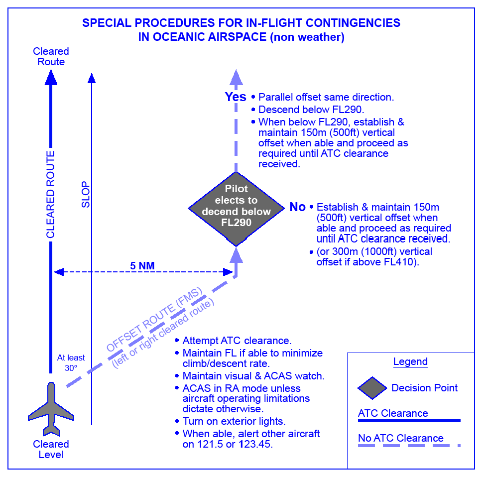
Note: Figure 3-1 provides an aid for understanding and applying the contingency procedures contained in paragraphs 3.11.2 and 3.11.3.
leave the assigned route or track by initially turning at least 30 degrees to the right or to the left in order to intercept and maintain a parallel, direction track or route offset 9.3 KM (5.0 NM). The direction of the turn should be based on one or more of the following:
aircraft position relative to any organised track or route system;
the direction of flights and flight levels allocated on adjacent tracks;
the direction of an alternate airport;
any strategic lateral offset being flown; and
terrain clearance;
the aircraft should be flown at a flight level and an offset track where other aircraft are less likely to be encountered;
maintain a watch for conflicting traffic both visually and by reference to ACAS (if equipped) leaving ACAS in RA mode at all times, unless aircraft operating limitations dictate otherwise;
turn on all aircraft exterior lights (commensurate with appropriate operating limitations);
keep the SSR transponder on at all times and, when able squawk 7700, as appropriate;
as soon as practicable, the pilot shall advise air traffic control of any deviation from assigned clearance;
use whatever means is appropriate (i.e. voice and/or CPDLC) to communicate during contingency or emergency;
if voice communication is used, the radiotelephony distress signal (MAYDAY) or emergency signal (PAN PAN), preferably spoken three times, shall be used as appropriate;
when emergency situations are communicated via CPDLC, the controller may respond via CPDLC. However, the controller may also attempt to make voice communication contact with the aircraft;
Note: Additional guidance on emergency procedures for controllers, radio operators and flight crew in data link operations can be found in the Global Operational Data Link (GOLD) Manual (Doc 10037).
establish communications with and alert nearby aircraft by broadcasting, at suitable intervals on 121.500 MHz (or, as a backup, on the inter-pilot air-to-air frequency 123.450 MHz) and where appropriate on the frequency in use: aircraft identification, the nature of the distress condition, intention of the person in command, position (including the ATS route designator or the track code, as appropriate) and flight level; and
the controller should attempt to determine the nature of the emergency and ascertain any assistance that may be required. Subsequent ATC action with respect to that aircraft shall be based on the intentions of the pilot and overall traffic situation.
3.11.3.1 If possible, maintain the assigned flight level until established on the 9.3 KM (5.0 NM) parallel, same direction track or route offset. If unable, initially minimize the rate of descent to the extent that is operationally feasible.
3.11.3.2 Once established on a parallel, same direction track or route offset by 9.3 KM (5.0 NM), either:
-
descend below FL 290, and establish a 150 M (500 FT) vertical offset from those flight levels normally used, and proceed as required by the operational situation or if an ATC clearance has been obtained, proceed in accordance with the clearance; or
Note: Descent below FL 290 is considered particularly applicable to operations where there is a predominant traffic flow (e.g. east-west) or parallel track system where the aircraft’s diversion path will likely cross adjacent tracks or routes. A descent below FL 290 can decrease the likelihood of conflict with other aircraft, ACAS RA events and delays in obtaining a revised ATC clearance.
-
establish a 150 M (500 FT) vertical offset (or 300 M (1000 FT) vertical offset if above FL 410) from those flight levels normally used, and proceed as required by the operational situation, or if an ATC clearance has been obtained, proceed in accordance with the clearance.
Note: Altimetry System Error may lead to less than actual 500 FT vertical separation when the above procedure is applied. In addition, with the 500 FT vertical offset applied, ACAS RAs may occur.
Figure 3-1. Visual aid for understanding and applying the contingency procedures guidance
Note: The following procedures are intended for deviation around adverse meteorological conditions.
3.11.4.1.1 When weather deviation is required, the pilot should initiate communications with ATC via voice or CPDLC. A rapid response may be obtained by either:
-
stating “WEATHER DEVIATION REQUIRED” to indicate that priority is desired on the frequency and for ATC response; or
-
requesting a weather deviation using a CPDLC lateral downlink message.
3.11.4.1.2 When necessary, the pilot should initiate the communications using the urgency call “PAN PAN” (preferably spoken three times) or by using a CPDLC urgency downlink message.
3.11.4.1.3 The pilot shall inform ATC when weather deviation is no longer required, or when a weather deviation has been completed and the aircraft has returned to its cleared route.
3.11.4.2 ACTIONS TO BE TAKEN WHEN CONTROLLER-PILOT COMMUNICATIONS ARE ESTABLISHED
3.11.4.2.1 The pilot should notify ATC and request clearance to deviate from track or route, advising, when possible, the extent of the deviation requested. The flight crew will use whatever means is appropriate (i.e. voice and/or CPDLC) to communicate during a weather deviation.
Note: Pilots are advised to contact ATC as soon as possible with requests for clearance in order to provide time for the request to be assessed and acted upon.
3.11.4.2.2 ATC should take one of the following actions:
-
When appropriate separation can be applied, issue clearance to deviate from track; or
-
If there is conflicting traffic and ATC is unable to establish appropriate separation. ATC shall;
-
Advise the pilot of inability to issue clearance for the requested deviation;
-
Advise the pilot of conflicting traffic; and
-
Request the pilot’s intentions.
-
3.11.4.2.3 The pilot should take the following actions:
-
comply with the ATC clearance issue; or
-
advise ATC of intentions and execute the procedures detailed in 3.11.4.3.
Note: The provisions of this section apply to situations where a pilot needs to exercise the authority of a pilot-in-command under the provisions of Annex 2, 2.3.1.
if possible, deviate away from an organized track or route system;
establish communications with and alert nearby aircraft by broadcasting, at suitable intervals: aircraft identification, flight level, position (including ATS route designator or the track code) and intentions, on the frequency in use and on 121.500 MHz (or, as a backup, on the inter-pilot air-to-air frequency 123.450 MHz);
watch for conflicting traffic both visually and by reference to ACAS (if equipped);
turn on all aircraft exterior lights (commensurate with appropriate operating limitations);
for deviations of less than 9.3 KM (5.0 NM) from the originally cleared track or route remain at a level assigned by ATC;
for deviations greater than or equal to 9.3 KM (5.0 NM) from the originally cleared track or route, when the aircraft is approximately 9.3 KM (5.0 NM) from track, initiate a level change in accordance with Table 3-1;
if the pilot receives clearance to deviate from cleared track or route for a specified distance and, subsequently, requests, but cannot obtain a clearance to deviate beyond that distance, the pilot should apply an altitude offset in accordance with Table 3-1 before deviating beyond the cleared distance.
when returning to track or route, be at its assigned flight level when the aircraft is within approximately 9.3 KM (5.0 NM) of the centre line; and
if contact was not established prior to deviating, continue to attempt to contact ATC to obtain a clearance. If contact was established, continue to keep ATC advised of intentions and obtain essential traffic information.
Note: If, as a result of actions taken under the provisions of 3.11.4.3.1, the pilot determines that there is another aircraft at or near the same flight level with which a conflict may occur, then the pilot is expected to adjust the path of the aircraft, as necessary, to avoid conflict.
Table 3-1
Originally cleared track or | Deviations | Level Changed |
|---|---|---|
EAST | LEFT | DESCEND 90 M (300 FT) |
| RIGHT | CLIMB 90 M (300 FT) | |
WEST | LEFT | CLIMB 90 M (300 FT) |
| RIGHT | DESCEND 90 M (300 FT) |
3.11.5.1 If the contingency procedures are employed by a twin-engine aircraft as a result of an engine shutdown or failure of an ETOPS critical system, the pilot should advise ATC as soon as practicable of the situation, reminding ATC of the type of aircraft involved, and request expeditious handling.
3.12 Procedure for Strategic Lateral Offsets in NAT Airspace
Note 1: The following incorporates lateral offset procedures for both the mitigation of the increasing lateral overlap probability due to increased navigation accuracy and wake turbulence encounters.
Note 2: The use of highly accurate navigation systems (such as the global navigation satellite system (GNSS)) by an increasing proportion of the aircraft population has had the effect of reducing the magnitude of lateral deviations from the route centre-line and, consequently, increasing the probability of a collision should a loss of vertical separation between aircraft on the same route occur.
Aircraft without automatic offset programming capability must fly the centre-line;
Though the majority of flights are able to perform offsets either 1 or 2 NM (whole nautical miles), flights able to perform SLOP procedure in tenths of a nautical mile should use that capability as it contributes to risk reductions;
It is recommended that pilots of aircraft capable of programming automatic offsets should randomly select flying centre-line or an offset. In order to obtain lateral spacing from nearby aircraft (i.e. those immediately above and/or below), pilots should use whatever means available (e.g. ACAS/TCAS, communications, visual acquisition, GPWS) to determine the best flight path to fly;
An aircraft overtaking another aircraft should offset within the confines of this procedure, if capable, so as to create the least amount of wake turbulence for the aircraft being overtaken;
The avoidance of wake turbulence (even in the OTS) can be accomplished effectively within the confines of the SLOP procedure, as specified above. Pilots may contact other aircraft on frequency 123.450 MHz, as necessary, to co-ordinate the best wake turbulence offset option;
Note: It is recognised that pilots will use their judgement to determine the action most appropriate to any given situation and have the final authority and responsibility for the safe operations of the aircraft.
Pilots may apply an offset outbound at the oceanic entry point and must return to centre-line at the oceanic exit point;
There is no ATC clearance required for this procedure and it is not necessary that ATC be advised;
Voice Position Reports should be based on the waypoints of the current ATC clearance and not on the offset positions;
Pilots should not offset to the left of centre-line nor offset more than 2 NM right of centre-line.
3.13 Adherence to ATC Approved Routes
Annex 2.
3.14 Flight Information Service
PANS Doc 4444 ATM/501.
3.15 Air Traffic Services Messages
Regional Supplementary Procedures DOC 7030. PANS Doc 4444 ATM/501.
3.16 Secondary Surveillance Radar (SSR)
Regional Supplementary Procedures DOC 7030.
Note: This procedure does not affect the use of Special Purpose Codes 7500, 7600 and 7700 in cases of unlawful interference, radio failure or emergency.
3.17 Action in the event of Air-Ground Communication Failure
follow the radio communication procedures of the airspace in which the aircraft is operating;
if the pilot elects to continue the flight, then enter oceanic airspace at the oceanic entry point at the level and speed resulting from the execution of the adjacent airspace radio communications failure (RCF) procedures then;
follow the procedures in 3.17.4.1 below.
The pilot shall maintain the currently cleared route, flight level and speed until reaching the Oceanic Exit Point.
No route, flight level or speed change shall be made before the Oceanic Exit Point unless a change is deemed necessary by the pilot in command to ensure the safety of the aircraft.
When being vectored or having been directed by ATC to proceed offset using RNAV without a specified limit, proceed in the most direct manner possible to re-join the current flight plan route no later than the next significant point, taking into consideration the applicable minimum flight altitude.
3.18 Minimum Aircraft System Performance Specification (MASPS)
Pre-PBN navigation:
The standard deviation of lateral track errors shall be less than 6.3 NM;
the proportion of total flight time spent by aircraft 30 NM or more off the cleared track shall be less than 5.3 x 10⁻⁴;
the proportion of the total flight time spent by aircraft between 50 and 70 NM off the cleared track shall be less than 13 x 10-5.
These mathematical standards can be approximated operationally as follows:
Aircraft must be operated so that lateral deviations from track remain less than 12.6 NM for at least 95 per cent of the time the system is required for navigation;
the navigation system must demonstrate a continuing capability to keep lateral deviations from cleared track in excess of 30 NM to less than 53 per 100 000 flight hours in the system; and
keep lateral deviations between 50 and 70 NM from cleared track to less than 13 per 100 000 flight hours in the system.
Area Navigation (RNAV) Specifications:
RNAV 10 (RNP 10) specification shall be applicable to navigation systems used to support a minimum lateral separation of 60 NM between aircraft that the requirements to operate in the NAT HLA provided that a portion of the route of the aircraft is within, above or below NAT HLA. In addition RNAV 10 can support a minimum lateral separation of 50 NM between aircraft operating in the New York Oceanic East FIR.
Required Navigation Performance (RNP) Specifications:
RNP 4 specification shall be applicable to navigation systems used to support minimum lateral separations as in (b) above and is required to support minimum lateral separations of 30 NM between aircraft operating within the control area of the New York Oceanic East FIR.
Note 1: Aircraft that have been NAT MNPS approved by the State of Registry or the State of the Operator prior to 1 January 2015 shall be permitted to operate in NAT HLA until 30 January 2020. As of 1 January 2015 new NAT MNPS approvals shall not be granted.
Note 2: RNAV 10 (RNP 10) and RNP 4 approved aircraft require a NAT HLA MNPS approval to demonstrate compliance with the MNPS established for the NAT HLA.
Note 3: Except for the navigational portion the requirements for a NAT HLA MNPS approval are equivalent to the 3 requirements that were associated with granting NAT MNPS approvals.
Aircraft must be operated so that lateral deviations from track remain less than 12.6 NM for at least 95 per cent of the time the system is required for navigation;
the navigation system must demonstrate a continuing capability to keep lateral deviations from cleared track in excess of 30 NM to less than 53 per 100 000 flight hours in the system; and
keep lateral deviations between 50 and 70 NM from cleared track, to less than 13 per 100 000 flight hours in the system.
The flight MUST have prior approval for operations in NAT HLA;
the approved aircraft minimum navigation installation MUST be serviceable and MUST have been checked for accuracy prior to entry into NAT HLA;
whilst in NAT HLA the approved operating procedures MUST be adhered to. Except in emergency, diversions from the ATC cleared track MUST NOT be made without prior approval of the controlling ATC Unit;
if subsequent unserviceability reduces the navigational capability below the required minimum for MNPS operations after entry into NAT HLA then the controlling ATC Unit MUST be advised so as to allow for any adjustments of separation from adjacent aircraft;
there MUST be a high standard of supervision, monitoring and cross checking of data inserted into automatic navigation system to prevent large errors arising from erroneous waypoint entries;
there MUST be a high standard of co-ordination with ATC Units to ensure that misunderstandings over the route to be flown do not occur.
Two fully serviceable Long Range Navigation Systems (LRNS).
A LRNS may be one of the following:One Inertial Navigation System (INS);
one Global Navigation Satellite System (GNSS); or
one navigation system using the inputs from one or more Inertial Reference System (IRS) or any other sensor system complying with the NAT HLA requirement.
each LRNS must be capable of providing to the flight crew with a continuous indication of the aircraft position relative to desired track.
it is highly desirable that the navigation system employed for the provision of steering guidance is capable of being coupled to the auto-pilot.
Note 1: currently the only GPS system fully operational and for which approval material is available is GPS.
Note 2: A GPS installation must be approved as follows:
If the two required LRNSs are both GPS they must be approved in accordance with the current version of FAA Advisory Circular AC-20—138D Appendix 1. AC-20-138 requires that GPS systems used in Oceanic airspace must have a FDE function. States other than the USA may set their own standards for operational approval of GPS to provide Primary Means of Navigation in Oceanic and remote areas but in all cases these approvals will include the requirement to carry out Pre-Departure Satellite Navigation Prediction Programmes. If, however, GPS serves as only one of the two required LRNSs then it must be approved in accordance with FAA TSO-C129 or later standard as Class A1, A2, B1, B2, C1 or C2 or with equivalent European Aviation Safety Agency (EASA) documentation ETSO-C129a. In this instance individual States vary in their insistence upon the need for the conduct of pre-departure satellite navigation prediction programmes (viz. FDE/RAIM).Note 3: Currently equivalent approval material for GLONASS is not under development but it will need to be available prior to approval of any GLONASS equipped aircraft for NAT HLA operations.
Via | Route Options | |
|---|---|---|
A | RIVOT/FORTY/STN/BAMRA/SUM | ATSIX - 61N 01234W - ALDAN - KFV (HF Required) |
RATSU - ALDAN - KFV | ||
B | ERNAN/NEVRI/REMSI/TLA/GOW | GOMUP - 60N 015W - 61N 01630W - BREKI - KFV (HF Required) |
C | KFV | SOPEN - DA - SF - YFB (HF Required) |
D | KFV | EPENI - 63N 030W - 61N 040W - OZN |
E | OZN | 59N 050W - AVUTI - PRAWN - YDP |
F | OZN | 59N 050W - CUDDY - PORGY - HO |
G | OZN | 58N 050W - HOIST - YYR |
Sufficient navigation capability remains to meet the MNPS and the requirements in Annex 6, Part I, Chapter 7 (paragraph 7.2 and paragraph 7.3) can be met by relying on the use of short-range navigation aids;
a revised flight plan is filed with the appropriate ATS Units; and
an appropriate ATC clearance is obtained.
Note 1: A revised oceanic ATC clearance will be issued after co-ordination between all the OAC's concerned.
Note 2: Should the Organized Track System at the time of the incident extend to the Northern part of the NAT Region, the aircraft concerned may be required to accept a lower than optimum flight level in its revised oceanic clearance, especially during peak traffic periods.
Note 3: The above guidance material in no way relieves the pilot from the obligation to take the best possible course of action in the light of prevailing circumstances.
Note: Routes A to G below, known as 'Blue Spruce' routes, have continuous VHF coverage at FL 300 and above except where stated.
Via | Route Options | |
|---|---|---|
A | RIVOT/FORTY/STN/BAMRA/SUM | ATSIX - 61N 01234W - ALDAN - KFV (HF Required) |
RATSU - ALDAN - KFV | ||
B | ERNAN/NEVRI/REMSI/TLA/GOW | GOMUP - 60N 015W - 61N 01630W - BREKI - KFV (HF Required) |
C | KFV | SOPEN - DA - SF - YFB (HF Required) |
D | KFV | EPENI - 63N 030W - 61N 040W - OZN |
E | OZN | 59N 050W - AVUTI - PRAWN - YDP |
F | OZN | 59N 050W - CUDDY - PORGY |
G | OZN | 58N 050W - HOIST - YYR |
H | T9 | LASNO - BEGAS (VHF, HF and ADS-B required) |
| J | T290 | ADVAT - GELPO (VHF, HF and ADS-B required) |
VALDI - MY - ING - KFV (G3);
PEMOS - MY (G11).
The flight MUST have prior approval for operations in NAT RVSM airspace;
the approved aircraft minimum altitude measuring installation MUST be serviceable and MUST have been checked for accuracy prior to entry into RVSM airspace;
whilst in RVSM airspace the approved operating procedures MUST be adhered to. Except in emergency, diversions from the ATC cleared Flight level MUST NOT be made without prior approval of the controlling ATC Unit;
if subsequent unserviceability reduces the altitude measuring capability below the required minimum for RVSM operations after entry into RVSM airspace then the controlling ATC Unit MUST be advised so as to allow for any adjustments of separation from adjacent aircraft;
there MUST be a high standard of supervision, monitoring and cross checking of altimeters to prevent a large discrepancy from the cleared flight level (less than 300 FT);
an automatic Altitude Keeping Device (AKD) should be operative and engaged during level cruise, except when circumstances such as the need to re-trim the aircraft or the onset of turbulence, require disengagement. In any event, adherence to cruise altitude should be accomplished by reference to one of the two primary altimeters;
there MUST be a high standard of co-ordination with ATC Units to ensure that misunderstandings over the cleared flight level do not occur.
at least two primary altitude measurement systems meeting the MASPS requirements;
a static source error correction (SSEC)/position error correction (PEC) must be applied automatically;
an altitude deviation warning system that shall alert when the altitude displayed to the flight crew deviates from selected altitude by more than a nominal value. This nominal value shall not be greater than 300 FT. For aircraft whose application for type certification was made after 1 January 1997, the nominal value should not be greater than 200 FT. The overall equipment tolerance in implementing this nominal value shall not exceed 50 FT; and
an automatic altitude-alerting device which is required to be capable of controlling altitude within +/- 65 FT of the selected altitude, when the aircraft is operated in straight and level flight, under non-turbulent, non-gust conditions.
if possible, establish increased vertical, longitudinal or lateral separation; or
suspend RVSM operations in the affected area.
Guidance and Information Material concerning Air Navigation in the NAT Region, including RVSM, is produced by and available from the ICAO Paris Office. The material in this Document deals primarily with planning and management of operations in the NAT Region and is mainly addressed to States and Operators;
The North Atlantic Operations and Airspace Manual. This manual has been developed specifically for use by pilots intending to operate in the NAT HLA. This manual is available for download from the EUR/NAT Regional Office section of the ICAO website www.icao.int.
Equipment and Installation Approvals:
The Chief Surveyor,
CAA Safety Regulation Group, Aviation House, South Area, London Gatwick Airport, West Sussex RH6 0YR.
Tel: +44-(0)1293-573362;
Operational Approvals:
Civil Aviation Authority, Flight Operations Department (Attn: Flight Operations Policy), Aviation House, 1W, South Area, London Gatwick Airport, West Sussex RH6 0YR.
Tel: +44-(0)1293-573521
Fax: +44-(0)1293-573991;
Further Information on other aspects of MNPS/RVSM Operations (including height-monitoring requirements):
North Atlantic Central Monitoring Agency, c/o NATS Limited, Room G41, Atlantic House, Fresson Avenue, Prestwick, Ayrshire, KA9 2GX.
Tel: +44-(0)1292-692412 HMU Status (recorded message)
Tel: +44-(0)1292-692760
Fax: +44-(0)1292-692754
Email: natcma@nats.co.uk
3.19 Routes Between Northern Europe and Spain/Canaries/Lisbon FIRs
Note: Operators should not file using the route designator T13, T16, T213, and should file full route coordinates for these routes.
3.20 Alerting and Search and Rescue Services
(See GEN 3.6 of the UK AIP).
3.21 Procedures — Westbound
-
Westbound flights are advised to flight plan the routes through UK Airspace that are offered by the Standard Routes Document published on the AIS CD-ROM.
-
Westbound flights departing from UK airports that are not listed are to flight plan via the published UK Upper ATS route structure.
-
For the UK Upper ATS Routes for the Westbound North Atlantic Flow refer to the Standard Routes Document published on the AIS CD-ROM.
3.22 Procedures - In the Event of Shanwick Oceanic Area Control Centre Evacuation
At least 3 minutes prior to the commencement of a climb or descent the flight should broadcast on the last assigned frequency, 121.500, 243.000 and 123.450 MHz the following:
ALL STATIONS
(callsign)
(direction)
DIRECT FROM (landfall fix) TO (Oceanic entry point)
LEAVING FLIGHT LEVEL (number) FOR FLIGHT LEVEL (number) AT (distance)(direction) FROM (Oceanic entry point) AT (time)
When the level change begins, the flight should make the following broadcast:
ALL STATIONS
(callsign)
(direction)
DIRECTION FROM (landfall fix) TO (Oceanic entry point)
LEAVING FLIGHT LEVEL (number) NOW FOR FLIGHT LEVEL (number)
When level, the flight should make the following broadcast:
ALL STATIONS
(callsign)
MAINTAINING FLIGHT LEVEL (number)
RATSU DCT GUNPA contact Reykjavik Oceanic Control - 126.750 MHz;
LUSEN DCT ELKOG DCT ORVIK contact Polaris Control - 135.675 MHz;
ATSIX DCT AKIVO DCT KLONN contact Polaris Control - 136.275 MHz;
ORTAV DCT ODPEX DCT ELSAN contact Copenhagen Control - 134.680 MHz;
BALIX DCT NINEX DCT ASKAM contact Maastricht Control - 132.085 MHz;
ADODO DCT AMTAP DCT ROKAN DCT TOPPA contact Maastricht Control - 132.085 MHz;
ERAKA DCT ETSOM DCT ERKIT contact London Control - 128.130 MHz;
ETILO DCT EVNAL DCT DCS DCT LAKEY contact London Control - 132.860 MHz;
GOMUP DCT GINGA DCT SOSIM contact London Control - 135.580 MHz.
3.23 Enquiries and Comments
Manager PC Procedures and Development,
Room F-059, NATS Prestwick, Prestwick Centre, Fresson Avenue, Prestwick, Ayrshire, KA9 2GX.
Tel: 01294-655300.
3.24 Format of NAT Company Preferred Routing Messages (CPR PRM)
Westbound:
(PRIORITY) (DESTINATION ADDRESS)
(DATE TIME OF ORIGIN) (ORIGIN ADDRESS)
(MESSAGE TYPE) — (COMPANY) — (WESTBOUND) — (YYMMDD AT 30W)
(DEP / DEST) (FIRST UK POINT) (ANCHOR POINT) (OCA RPS) (LANDFALL)
(INLAND FIX) (NUMBER OF FLIGHTS (01 — 99))
Note: If there is no INLAND FIX then the latitude at 80W is to be used.
Example:
FF EGGXZOZX EGTTZDZX CZQXZQZX CZQMZQZX CZULZQZX CYHQZDZX BIRDZQZX LPPOZOZX KZNYZRZX KCFCZDZX
111824 LSZHSWRW
PRM — SWR — W — 930212 —
LSZH / KJFK BNE BEL 55/10 56/20 57/30 55/40 53/50 YAY TOPPS 02
LSZH / KIAD BNE BURAK 53/15 53/20 52/30 51/40 50/50 YQX TUSKY 01
Eastbound:
(PRIORITY) (DESTINATION ADDRESS)
(DATE TIME OF ORIGIN) (ORIGIN ADDRESS)
(MESSAGE TYPE) — (COMPANY) — (EASTBOUND) — (YYMMDD AT 30W)
(DEP / DEST) (INLAND FIX) (ANCHOR POINT) (OCA RPS) (LANDFALL)
(LAST UK POINT) (NUMBER OF FLIGHTS (01 — 99))
Note: If there is no INLAND FIX then the latitude at 80W is to be used.
Example:
FF EGGXZOZX EGTTZDZX CZQXZQZX CZQMZQZX CZULZQZX CYHQZDZX BIRDZQZX LPPOZOZX KZNYZRZX KCFCZDZX
120936 EHAMKLMW
PRM — KLM — E — 930213 —
KJFK / EHAM TOPPS YAY 53/50 53/40 54/30 54/20 54/15 BABAN LAMSO 03
CYMX / EHAM YML FOXXE 57/50 58/40 58/30 57/20 56/10 MAC LAMSO 01
3.25 Format of NAT Company Preferred Route Flight Plan day minus 1 (CPR FPL-1)
Examples:
The CPR_ID is a seven character code defined as follows:
Airline ICAO Code | British Airways: | BAW |
Preferred Route Indicator | P (does not change) | P |
Westbound | W | W |
Company Preferred Route ID Number (00-99) | Correlates to set departure/destination | 01 |
The resulting CPR_ID in this example is BAWPW01 | ||
Example 1 – (Indicating CPR_ID 01 for British Airways)
CPR (FPL-1) sent to EGGXGATT on the 04/08/2016 for a Westbound OTS Design for the 05/08/2016.
(FPL-BAWPW01-IS
-B772/H-SDE1E3FGHIJ3J5J6M1M2RWXYZ/LB1D1
-EGLL1030
-N0487F340 CPT3G CPT Q63 KENET UL9 STU/N0490F360 UL9 SLANY DCT DINIM/M083F360 DCT 50N020W 45N030W 38N040W/M083F380 35N045W 31N050W 20N060W DCT ANU DCT
-TAPA0752
-PBN/A1B1D1O1S2 NAV/RNVD1E2A1 SUR/TCAS DOF/160805 REG/BA777 EET/EISN0032 EGGX0119 50N020W0146 LPPO0253 KZWY0412 35N045W0452 31N050W0536 20N060W0723 TTZP0743 CODE/4007F9 OPR/BAW RVR/075 RMK/TCAS)
Example 2 – (Indicating CPR_ID 23 for British Airways)
CPR (FPL-1) sent to EGGXGATT on the 04/08/2016 for a Westbound OTS Design for the 05/08/2016.
(FPL-BAWPW23-IS
-B744/H-SDE1E3FGHIJ3J5J6M1M2RWXYZ/LB1D1
-EGLL1030
-N0490F300 CPT5J CPT Q63 KENET N14 UGNUS UN14 BAKUR DCT KORAK DCT CON DCT REVNU/M082F300 DCT SUNOT/M082F300 DCT 59N020W/M082F320 61N030W/M082F340 61N040W/M082F360 DCT NA DCT 61N050W DCT RADUN N822A PEPKI/N0481F360 N822A LOPVI DCT 58N070W
5430N08000W/N0483F380 4930N09000W DCT KP12G/N0489F400 DCT KP84A DCT KD66U DCT EKR J100 BCE GRNPA1
-KLAS0952
-PBN/A1B1D1O1S2 NAV/RNVD1E2A1 SUR/TCAS DOF/160805 REG/BA744 EET/EISN0030 EGGX0056 SUNOT0122 59N020W0146 CZQX0226 61N040W0303 BGGL0307 NA0324 61N050W0342 CZQX0350 RADUN0413 CZUL0427 CZWG0552 KZMP0704 KZDV0807 KZLC0913 KZLA0933 CODE/4006B2 OPR/BAW RVR/075 RMK/NRP TCAS)
Example of CPR_ID TABLE
ICAO AL | IATA AL | Carrier1Name | Market Pair | Dep Airport | Arr Airport | Unique |
|---|---|---|---|---|---|---|
BAW | BA | British Airways | ANU-LGW | LGW | ANU | BAWPW01 |
BAW | BA | British Airways | ATL-LHR | LHR | ATL | BAWPW02 |
BAW | BA | British Airways | AUS-LHR | LHR | AUS | BAWPW03 |
BAW | BA | British Airways | BDA-LGW | LGW | BDA | BAWPW04 |
BAW | BA | British Airways | BGI-LGW | LGW | BGI | BAWPW05 |
3.26 DESTINATION ADDRESS CODE:
|
PRM format: | ||
|
EGGXZOZX — Shanwick |
CZQXZQZX — Gander |
CZULZQZX — Montreal |
|
EGTTZDZX — London FMU |
CZQMZQZX — Moncton |
CYHQZDZX — TCA ARU |
|
BIRDZQZX — Reykjavik |
LPPOZOZX — Santa Maria |
KZNYZRZX — New York |
|
KCFCZDZX — FAA Central Flow | ||
FPL-1 format:
EGGXGATT — Shanwick
Note: Shanwick can receive Company Preferred Route data in both PRM or FPL-1 formats at EGGXGATT. The AFTN address EGGXZOZX is only available for Company Preferred Route data in PRM format.
4 En-Route Transponder Mandatory Zones
|
Designation and Lateral Limits |
Vertical Limits and Classification |
Controlling Authority |
|---|---|---|
|
Burbo Bank TMZ (Area A) |
3500 FT |
Warton APP (129.530 MHz) between Mon-Thu 0730-1900 (0630-1800), Fri 0730-1700 (0630-1600). |
|
Burbo Bank TMZ (Area B) |
2000 FT |
Warton APP (129.530 MHz) between Mon-Thu 0730-1900 (0630-1800), Fri 0730-1700 (0630-1600). |
|
Burbo Bank TMZ (Area C) |
FL 45 |
Warton APP (129.530 MHz) between Mon-Thu 0730-1900 (0630-1800), Fri 0730-1700 (0630-1600). |
|
Note: See also ENR 6-28. For aircraft equipped with and operating secondary surveillance radar equipment, as defined in GEN 1.5 paragraph 5.3, access to the Burbo Bank TMZ is not subject to ATC approval. Access to the Burbo Bank TMZ without serviceable transponder equipment, as defined in GEN 1.5 paragraph 5.3, is subject to specific approval of the Controlling Authority. | ||
|
Designation and Lateral Limits |
Vertical Limits and |
Controlling Authority |
|---|---|---|
|
Greater Wash TMZ - the area bounded by: |
FL 100 |
Anglia Radar (125.275 MHz (backup 128.925 MHz)) - from surface up to and including FL 65, between 0630-2200 (0530-2100). |
|
Note: For aircraft equipped with and operating secondary surveillance radar equipment, as defined in GEN 1.5 paragraph 5.3, access to the Greater Wash TMZ is not subject to ATC approval. Access to the Greater Wash TMZ without serviceable transponder equipment, as defined in GEN 1.5 paragraph 5.3, is subject to specific approval of the Controlling Authority. | ||
|
Designation and Lateral Limits |
Vertical Limits and Classification |
Controlling Authority |
|---|---|---|
|
Humber Gateway TMZ - the area bounded by: |
FL 100 |
Anglia Radar (128.925 MHz (backup 125.275 MHz)) - from surface up to and including FL 65, between 0630-2200 (0530-2100). |
|
Note: For aircraft equipped with and operating secondary surveillance radar equipment, as defined in GEN 1.5 paragraph 5.3, access to the Humber Gateway TMZ is not subject to ATC approval. Access to the Humber Gateway TMZ without serviceable transponder equipment, as defined in GEN 1.5 paragraph 5.3, is subject to specific approval of the Controlling Authority. | ||
|
Designation and Lateral Limits |
Vertical Limits and Classification |
Controlling Authority |
|---|---|---|
|
London Array (Area A) |
FL 65 |
Southend Radar |
|
London Array (Area B) |
5500 FT |
Southend Radar |
|
Note 1: Providing aircraft have and operate secondary surveillance radar equipment, as defined in GEN 1.5 paragraph 5.3, access to the London Array TMZ is not subject to ATC approval. Note 2: The pilot of an aircraft that wishes to operate in the London Array TMZ without serviceable transponder equipment as defined in GEN 1-5 paragraph 5.3 may be granted access to the TMZ subject to specific ATC approval. This approval may be obtained from Southend Radar/Approach on frequency 130.780 MHz. | ||
|
Designation and Lateral Limits |
Vertical Limits and Classification |
Controlling Authority |
|---|---|---|
|
Moray Firth TMZ - the area bounded by: |
FL 100 |
Lossie Departures (119.575 MHz), H24 from surface up to and including FL 100. Class E approval for VFR transits only. |
|
Note: For aircraft equipped with and operating secondary surveillance radar equipment, as defined in GEN 1-5 paragraph 5.3, access to the Moray Firth TMZ is not subject to ATC approval. Access to the Moray Firth TMZ without serviceable transponder equipment, as defined in GEN 1-5 paragraph 5.3, is subject to specific approval of the Controlling Authority. The TMZ incorporates parts of Y904 (Class E) and EGD809S; the more stringent relevant airspace classification regulations apply. | ||
|
Designation and Lateral Limits |
Vertical Limits and Classification |
Controlling Authority |
|---|---|---|
|
Neart na Gaoithe TMZ - the area bounded by: 562136.64N 0021426.73W-561532.40N 0020809.60W-561228.80N 0020722.80W-561228.80N 0021619.20W-561549.59N 0022003.29W-561725.83N 0022013.94W-562009.60N 0021825.20W-562136.64N 0021426.73W. |
FL 100 |
The Controlling Authority is Leuchars. |
|
Note: For aircraft equipped with and operating secondary surveillance radar equipment, as defined in GEN 1.5 paragraph 5.3, access to the Neart na Gaoithe TMZ is not subject to ATC approval. Access to the Neart na Gaoithe TMZ without serviceable transponder equipment, as defined in GEN 1.5 paragraph 5.3, is subject to specific approval of the Controlling Authority. | ||
|
Designation and Lateral Limits |
Vertical Limits and Classification |
Controlling Authority |
|---|---|---|
|
Seagreen TMZ (Phase 1) - the area bounded by: 562848.316N 0015621.635W -562856.706N 0015742.338W - 562919.903N 0015849.297W - 562953.266N 0015935.362W -563026.418N 0015955.875W -563100.251N 0015959.339W - 564040.162N 0015951.322W -564116.339N 0015940.636W - |
FL 100 |
No Controlling Authority. Contact Scottish FIS (119.875 MHz) H24 from SFC up to and including FL 55 for flight information. Flights transiting P18 when active between waypoints UPGET and OKPAL should contact Scottish Control (124.500 MHz). |
|
Note: For aircraft equipped with and operating SSR equipment, as defined in GEN 1-5 paragraph 5.3, access to the Seagreen TMZ (Phase 1) is not subject to ATC approval. The TMZ incorporates parts of P18 (Class D) and EGD613C; within these areas the more stringent relevant airspace classification regulations apply. | ||
|
Designation and Lateral Limits |
Vertical Limits and Classification |
Controlling Authority |
|---|---|---|
|
Walney TMZ |
FL 100 |
Warton APP (129.530 MHz) between Mon-Thu 0730-1900 (0630-1800), Fri 0730-1700 (0630-1600). |
|
Note: See also ENR 6-28. For aircraft equipped with and operating secondary surveillance radar equipment, as defined in GEN 1.5 paragraph 5.3, access to the Walney TMZ is not subject to ATC approval. Access to the Walney TMZ without serviceable transponder equipment, as defined in GEN 1.5 paragraph 5.3, is subject to specific approval of the Controlling Authority. | ||
5 En-Route Radio Mandatory Zones
|
Designation and Lateral Limits |
Vertical Limits and Classification |
Controlling Authority |
|---|---|---|
|
Ekofisk RMZ |
1500 FT |
Ekofisk HFIS 130.550 MHz |
6 UK Free Route Airspace - Non-standard Planning Zone (NPZ)
| Identification and Name Lateral Limits | Upper Limit Lower Limit | Purpose |
|---|---|---|
| EGNPZ1 GOMUP 570000N 0100000W following the line of latitude to - 570000N 0095810.29W - 564500N 0095811.02W following the line of latitude to - 564500N 0100000W - 570000N 0100000W | Upper Limit: FL 660 Lower Limit: FL 255 | To prevent traffic from filling a flight plan across the NOTA/Scottish UIR boundary and conflicting with traffic entering or leaving Shanwick Oceanic airspace via GOMUP. Shall not prevent use of GOMUP as an Entry and Exit from FRA. |
| EGNPZ2 GUNPA 604500N 0000000E following the line of latitude to - 604500N 0000202.26W - 610000N 0000203.22W following the line of latitude to - 610000N 0000000E - 604500N 0000000E | Upper Limit: FL 660 Lower Limit: FL 255 | To prevent traffic from filling a flight plan across the Polaris/Scottish UIR boundary and conflicting with traffic entering or leaving Reykjavik Oceanic airspace via GUNPA. Shall not prevent use of GUNPA as a crossing point between Polaris and Reykjavik UIRs. |
| EGNPZ3 WEST NPZ 3 515232.28N 0024010.91W - 524354.41N 0024121.20W - 524443.68N 0024250.72W - 515252.89N 0024426.80W - 502125.60N 0030449.43W - 501945.78N 0030057.03W - 515232.28N 0024010.91W | Upper Limit: FL 660 Lower Limit: FL 245 | To segregate and manage complex traffic flows at the flight planning stage. |
| EGNPZ4 WEST NPZ 4 525400.43N 0025127.56W - 525357.04N 0025033.17W - 515258.18N 0025249.02W - 503149.80N 0030806.14W - 504155.35N 0031128.89W - 515254.95N 0025712.89W - 525400.43N 0025127.56W | Upper Limit: FL 660 Lower Limit: FL 245 | To segregate and manage complex traffic flows at the flight planning stage. |
| EGNPZ5 WEST NPZ 5 524901.25N 0030041.94W - 524905.00N 0025908.55W - 515225.52N 0030458.06W - 502548.78N 0032033.18W - 502830.84N 0032327.46W - 515237.45N 0030811.10W - 524901.25N 0030041.94W | Upper Limit: FL 660 Lower Limit: FL 245 | To segregate and manage complex traffic flows at the flight planning stage. |
| EGNPZ6 WEST NPZ 6 524331.96N 0031324.32W - 524333.84N 0031214.24W - 514428.44N 0031709.99W - 502232.59N 0033253.61W - 502609.35N 0033607.45W - 513849.08N 0032151.59W - 524331.96N 0031324.32W | Upper Limit: FL 660 Lower Limit: FL 245 | To segregate and manage complex traffic flows at the flight planning stage. |
| EGNPZ7 WEST NPZ 7 525424.21N 0031452.52W - 525429.44N 0031716.49W - 523653.49N 0032636.07W - 515701.32N 0033257.83W - 494050.61N 0035225.34W - 494105.00N 0034912.00W - 515714.71N 0032638.20W - 523656.80N 0032324.01W - 525424.21N 0031452.52W | Upper Limit: FL 660 Lower Limit: FL 245 | To segregate and manage complex traffic flows at the flight planning stage. |
| EGNPZ8 WEST NPZ 8 522000.00N 0053000.00W - 514624.84N 0014120.19W - 514323.89N 0014118.50W - 521502.10N 0053000.00W - 522000.00N 0053000.00W | Upper Limit: FL 660 Lower Limit: FL 245 | To segregate and manage complex traffic flows at the flight planning stage. |
| EGNPZ9 WEST NPZ 9 520557.01N 0050228.17W - 515420.01N 0032420.63W - 514757.76N 0023846.62W - 515056.17N 0032840.85W - 520230.02N 0050100.39W - 520557.01N 0050228.17W | Upper Limit: FL 660 Lower Limit: FL 245 | To segregate and manage complex traffic flows at the flight planning stage. |
| EGNPZ10 WEST NPZ 10 514141.64N 0014827.94W - 513956.97N 0014842.45W - 513937.94N 0022445.85W - 514409.13N 0033454.21W - 515551.57N 0050732.32W - 520037.42N 0051836.75W - 515904.68N 0050457.05W - 514756.26N 0033438.00W - 514239.53N 0015547.90W - 514141.64N 0014827.94W | Upper Limit: FL 660 Lower Limit: FL 245 | To segregate and manage complex traffic flows at the flight planning stage. |
| EGNPZ11 WEST NPZ 11 514840.78N 0050540.20W - 515245.80N 0051912.90W - 515310.90N 0051355.47W - 514055.53N 0033435.14W - 513327.53N 0014013.64W - 512932.76N 0014129.61W - 513720.16N 0033651.76W - 514840.78N 0050540.20W | Upper Limit: FL 660 Lower Limit: FL 245 | To segregate and manage complex traffic flows at the flight planning stage. |
| EGNPZ12 WEST NPZ 12 512314.52N 0014537.95W - 512709.27N 0014250.98W - 513331.62N 0033615.95W - 514408.88N 0044650.29W - 515105.30N 0055829.55W - 514633.42N 0060342.44W - 514249.13N 0044659.98W - 513021.80N 0033654.63W - 512314.52N 0014537.95W | Upper Limit: FL 660 Lower Limit: FL 245 | To segregate and manage complex traffic flows at the flight planning stage. |
| EGNPZ13 WEST NPZ 13 511758.38N 0013459.68W - 512704.32N 0034420.14W - 514343.55N 0063229.94W - 514153.33N 0063325.89W - 512403.05N 0034336.90W - 511758.38N 0013459.68W | Upper Limit: FL 660 Lower Limit: FL 245 | To segregate and manage complex traffic flows at the flight planning stage. |
7 Channel Islands Airspace - EGJT
Purpose: To describe the complete volume of airspace delegated to Jersey by both the UK and French authorities and collectively identified as Channel Islands Airspace with the ICAO designator: EGJT.
| CHANNEL ISLANDS AIRSPACE - ICAO: EGJT | ||
|---|---|---|
| Vertical Limits, Classification and associated FIRs |
Lateral Limits | Remarks |
|
[TMA] FL 80 - FL 195 Class A Airspace[CTA] FL 55 - FL 80 Class D Airspace |
500000N 0030000W –493500N 0030000W –500000N 0032000W following the line of latitude to –500000N 0030000W. | Controlling Authority: JERSEY ATC 0545-2100 (0445-2030) and by arrangement. Outside Jersey notified hours the airspace adopts the classification appropriate to airway or uncontrolled airspace designation, as appropriate for the respective FIR, as detailed in the UK and France AIPs. During the notified hours of operation of Jersey ATC, the airspace is operated in accordance with Air Navigation (Jersey) Law 2014 and Air Navigation (Rules of the Air) (Jersey) Regulations 2017. Note: Regulations as per Standardised European Rules of the Air (SERA) but established by the Air Navigation (Jersey) Law 2014. UK SERA derogations do not apply in Channel Island Airspace JERSEY MET issue SIGMET for EGJT. |
|
[TMA] FL 80 - FL 195 Class A Airspace[CTA] 3500 FT ALT - FL 80 Class D Airspace |
500000N 0020000W following the line of latitude to –500000N 0014700W –494400N 0020000W –500000N 0020000W. | |
|
[TMA] FL 80 - FL 195 Class A Airspace[CTR] SFC - FL 80 Class D Airspace |
500000N 0020000W –493000N 0020000W –490200N 0014000W following the line oflatitude to –490200N 0030000W –500000N 0030000W following the line oflatitude to –500000N 0020000W. | |
|
Note: The above airspace is an amalgamation of the Channel Islands CTA1 North, CTA1 South, CTA2, CTR North, CTR South, TMA North & TMA South as detailed in ENR 2.1 and EGJJ AD 2.17 and identified on chart ENR 6-40. | ||
| Forecast and SIGMET services within Channel Islands Airspace are provided by JERSEY MET (EGJX). | ||