1 Notification
1.1 The Selected Transition Altitudes listed in paragraph 4 are notified for the purposes of SERA.3110 Cruising Levels, SERA.5005 Visual Flight Rules and SERA.5020 IFR - Rules Applicable to IFR Flights within Controlled Airspace.
1.2 For the purpose of SERA.5005(g), aircraft in level cruising flight and operated in accordance with the visual flight rules above 3000 FT AMSL are not required to be flown at a cruising level appropriate to its magnetic track unless flying in conformity with the conditions specified by the appropriate air traffic control unit.
1.3 For the purposes of SERA.5025(a), an aircraft in level flight outside controlled airspace at or below 3000 FT AMSL and operated in accordance with the instrument flight rules is not required to be flown at a cruising level appropriate to its magnetic track if it flies:
in conformity with the instructions of the appropriate air traffic service unit; or
in accordance with holding procedures notified in relation to an aerodrome.
3 General Procedures
3.1 The Transition Altitude within the UK is 3000 FT except in, or beneath, that Airspace specified at paragraph 4.1.
3.2 Transition Altitudes are shown in the aerodrome directory in AD 2.17 as well as on aerodrome Approach and ATC Surveillance Minimum Altitude Charts.
3.3 The vertical position of aircraft at, or below, any Transition Altitude will normally be expressed in terms of Altitude. The vertical position at, or above, any Transition Level will normally be expressed in terms of Flight Level. When descending through the Transition Layer the vertical position will be expressed by pilots in terms of Altitude, and when climbing in terms of Flight Level. The Transition Altitude and the Transition Level may be used concurrently in cruising flight, with vertical separation ensured.
3.4 Flight Levels are measured with reference to the Standard Pressure datum of 1013.25 hPa. In the UK, the first available Flight Level above the Transition Altitude is separated from the Transition Altitude by a minimum pressure interval corresponding to a nominal 1000 FT in the ISA. Consecutive IFR cruising Flight Levels above the Transition Level are separated by pressure intervals corresponding to 1000 FT in the ISA up to and including FL 410 and by pressure intervals corresponding to 2000 FT in the ISA above FL 410. Cruising level requirements are detailed at ENR 1.7, paragraph 6.1. FL 195 will not be allocated as a cruising level.
3.5 QNH reports should be obtained from an ATS Unit. These QNH values are rounded down to the nearest whole hectopascal but are available at certain aerodromes in tenths of hectopascals for landing aircraft on request.
3.6 Altimeter setting procedures at military aerodromes may vary from those detailed in this section.
3.7
Altimeter Setting Regions (ASR). To make up for any lack of stations reporting actual QNH, the UK has been divided into a number of ASRs for each of which the National Meteorological Office calculates the lowest forecast QNH (Regional Pressure Setting) for each hour. These values are available hourly for the period H+1 to H+2 and may be obtained from all aerodromes having an Air Traffic Service, from London AC (Swanwick) and Scottish AC (Prestwick), or by telephone.
3.8 The ASRs are listed below together with the MET Office Codes. The area covered by the Regions are shown on the combined Flight Information Region (FIR) and ASR Chart at ENR 6-18.
Skerry (01) | Holyhead (07) | Chatham (12) | Orkney (17) |
Portree (02) | Barnsley (08) | Portland (13) | Marlin (18) |
Rattray (03) | Humber (09) | Yarmouth (14) | Petrel (19) |
Tyne (04) | Scillies (10) | Cotswold (15) | Skua (20) |
Belfast (05) | Wessex (11) | Shetland (16) | Puffin (21) |
3.9 Airspace within all Control Zones (CTRs), and within and below all Terminal Control Areas (TMAs), Control Areas (CTAs) except Airways and the Worthing and Clacton Control Areas, during their notified hours of operation, does not form part of the ASR Regional Pressure Setting system.
3.10 When flying in Airspace below TMAs and CTAs detailed above, pilots should use the QNH of an adjacent aerodrome when flying at or below the Transition Altitude. It may be assumed that for aerodromes located beneath such Areas, the differences in the QNH values are insignificant. When flying beneath Airways whose base levels are expressed as Altitudes pilots are recommended to use the QNH of an adjacent aerodrome in order to avoid penetrating the base of Controlled Airspace.
3.11 Pilots operating north of 6130N within the Airspace detailed at ENR 2.2, paragraph 1.1 when not receiving a service from Sumburgh Radar are advised to set the Puffin Regional Pressure Setting as the pressure datum whilst flying at or below 3000 FT.
3.12 The QNH settings to be used within the Northern North Sea Radar Service Areas are shown at ENR 6-23.
5 Detailed Procedures
5.1
Take-off and climb
5.1.1 A QNH altimeter setting is given with the taxiing clearance prior to take-off.
5.1.2 At UK aerodromes the designated location for pre-flight altimeter checks is the apron.
5.1.3 For all major UK aerodromes, the apron elevation (or the elevation of various parts of an apron where there is significant variation between them) has been determined and the value is displayed in the flight clearance office at the aerodrome concerned. It is also given at AD 2.8.
5.1.4 Within Controlled Airspace a pilot should set one altimeter to the latest Aerodrome QNH prior to take-off. While flying at, or below, the Transition Altitude vertical position will be expressed in terms of altitude based upon the Aerodrome QNH. When cleared for climb to a Flight Level, vertical position will be expressed in terms of Flight Level, unless intermediate altitude reports have been specifically requested by Air Traffic Control.
5.1.5 Outside Controlled Airspace, a pilot may use any desired setting for take-off and climb. However, when under IFR, vertical position must be expressed in terms of Flight Level on climbing through the Transition Altitude.
5.1.6 Pilots taking-off at aerodromes beneath Terminal Control Areas and Control Areas should use aerodrome QNH when flying below the Transition Altitude and beneath these Areas, except that the aerodrome QFE may be used when flying within the circuit. It may be assumed that for aerodromes beneath the same TMA or CTA the differences in their QNH values are insignificant.
5.2
En-route
5.2.1
Within Controlled Airspace
5.2.1.1 At and above the transition level and during en-route flight the aircraft should be flown at Flight Levels. The latest and most appropriate Regional Pressure Setting value is to be used for checking terrain clearance in flight. Aircraft flying in a Control Zone or TMA at an Altitude at or below the Transition Altitude will be given the appropriate QNH setting in their clearance to enter the Zone/TMA.
5.2.2
Outside Controlled Airspace and within Active TRAs
5.2.2.1 In flight at or below 3000 FT AMSL, pilots may use any desired setting. However, pilots flying beneath a TMA or CTA should obtain the QNH from an aerodrome situated beneath that area when flying below the Transition Altitude. It may be assumed that for aerodromes beneath the same TMA or CTA, the differences in the QNH values are insignificant. References to vertical position in flight plans and communications with ATC are to be expressed in terms of altitude.
5.2.2.2
Outside Controlled Airspace
-
IFR. When flying under IFR above the Transition Altitude, pilots must have 1013.2 hPa selected on an altimeter and conform to the cruising levels at ENR 1.7 paragraph 6.1. An aircraft in level flight operated in accordance with the instrument flight rules outside controlled airspace at or below 3000 FT AMSL is not required to conform with the cruising levels at ENR 1.7 paragraph 6.1 if it is flown in conformity with the instructions of the appropriate air traffic service unit; or in accordance with holding procedures notified in relation to an aerodrome.
-
VFR. When flying under VFR, aircraft in level cruising flight and operated in accordance with the visual flight rules above 3000 ft amsl are not required to conform with the cruising levels at ENR 1.7 paragraph 6.1 unless flying in conformity with the conditions specified by the appropriate air traffic control unit. The latest and most appropriate lowest forecast Regional Pressure Setting value should be used for checking terrain clearance.
5.2.2.3
Flight within Active TRAs
-
IFR. When flying under IFR above the Transition Altitude, pilots must have 1013.2 hPa selected on an altimeter and conform with the cruising level requirements at ENR 1.7, paragraph 6.1.
-
VFR. When flying under VFR, pilots are recommended to conform with the cruising level requirements at ENR 1.7, paragraph 6.1. The latest and most appropriate lowest forecast Regional Pressure Setting value should be used for checking terrain clearance.
5.3
Approach and Landing
5.3.1 When an aircraft is descended from a Flight Level to an Altitude preparatory to commencing approach for landing, ATC will pass the appropriate aerodrome QNH. In addition, ATC will also pass the Transition Level in due time prior to reaching it during descent either by voice communications, ATIS broadcast or if available, data link. On vacating the Flight Level, the pilot will change to the aerodrome QNH unless further Flight Level vacating reports have been requested by ATC, in which case, the aerodrome QNH will be set following the final Flight Level vacating report. Thereafter, the pilot will continue to fly on the aerodrome QNH until established on final approach. When requested by the pilot or local procedures require, the appropriate QFE and aerodrome or threshold elevation shall also be given.
5.3.2
When carrying out a radar approach, ATC will assume that an aircraft is using QNH on final approach and will include a reminder of the appropriate QNH setting in the RTF phraseology. If the pilot requests to undertake the approach using QFE, then ATC will pass the appropriate QFE and 'height' will be substituted for 'Altitude' in the RTF phraseology. It should be noted that the Obstacle Clearance Height is always given with reference to the aerodrome or threshold elevation.
5.3.3 Pilots landing at aerodromes beneath Terminal Control Areas and Control Areas should use aerodrome QNH when flying below the Transition Altitude and beneath these Areas, except that the aerodrome QFE may be used when flying within the circuit. It may be assumed that for aerodromes within the boundary of the same TMA or CTA, differences in their QNH values are insignificant.
5.3.4 The threshold elevation of each instrument runway that is 7 ft or more below the aerodrome elevation is given at AD 2.12. The barometric pressure setting to be used for landing on such a runway will be passed by ATC as QNH . . . . threshold elevation . . . . , or QFE . . . . threshold . . . . .
Note: At USAF operated aerodromes QFE is not used. All procedures below the Transition Altitude will be based on aerodrome QNH, and all vertical displacements given as altitudes. Aerodrome QFE will be available on request.
5.4
Missed Approach
5.4.1 In the event of a missed approach, pilots may continue to use the altimeter setting selected for final approach, but reference to the vertical position of the aircraft exchanged in communication with ATC should be expressed in terms of altitude on aerodrome QNH, unless otherwise instructed by ATC.
5.5
Flight Planning
5.5.1 The levels at which a flight is to be conducted are to be specified in the flight plan:
In terms of flight level numbers for that part of the flight to be conducted at or above the transition level; and
in terms of altitudes (ft) for that part of the flight at or below the Transition Altitude.
5.5.2 The flight level or levels selected for a flight should ensure adequate terrain clearance at all points along the route to be flown, should meet Air Traffic Service requirements and comply with the cruising levels at ENR 1.7, paragraph 6.1, where applicable.
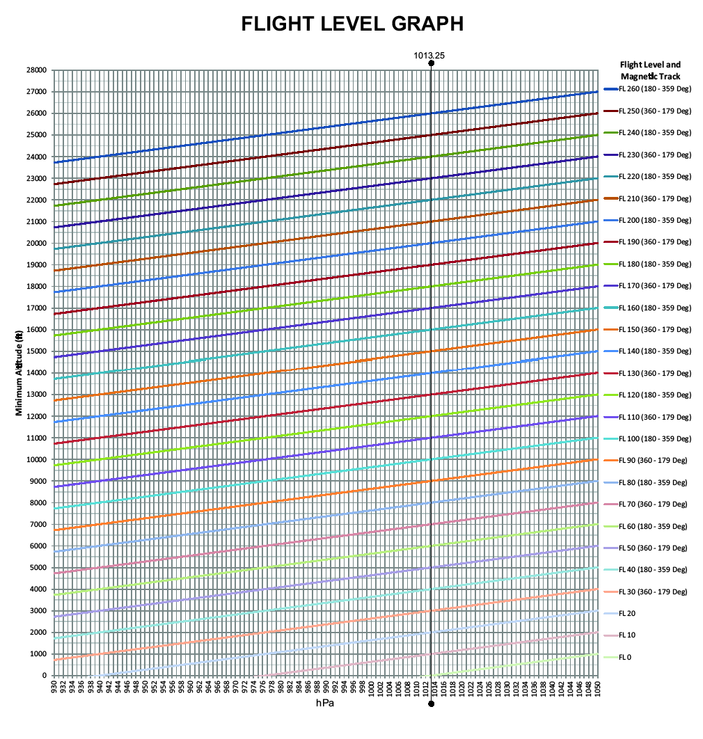
5.5.3 The information required to determine the lowest flight level to ensure adequate terrain clearance may be obtained from the appropriate Air Traffic Service Unit or Meteorological Office. A chart for converting QNH values to flight levels for this purpose is shown at ENR 1.7-5.
5.5.4 The Transition Altitude applicable to the aerodromes of departure and destination and for alternate aerodromes should be noted.
5.5.5 Flight levels are to be specified in the flight plan by number and not in terms of ft as is the case with altitudes.
5.5.6 When flight plans are filed for IFR flights above 3000 FT AMSL outside Controlled Airspace in the UK, the cruising level must be selected from the appropriate table at paragraph 6.1.